Weather Alert in Nebraska
Red Flag Warning issued February 17 at 12:04AM CST until February 17 at 8:00PM CST by NWS North Platte NE
AREAS AFFECTED: Eastern Panhandle/Crescent Lake NWR; Frenchman Basin; Loess Plains
DESCRIPTION: ...THIS IS A PARTICULARLY DANGEROUS SITUATION... * AFFECTED AREA...Fire Weather Zone 204 Eastern Panhandle/Crescent Lake NWR, Fire Weather Zone 210 Frenchman Basin and Fire Weather Zone 219 Loess Plains. * TIMING...11 AM to 7 PM MST (Noon to 8 PM CST) Today. * WINDS...West 30 to 40 mph with gusts 45 to 55 mph. Highest gusts will be in the western Sandhills and southeastern Nebraska Panhandle. * RELATIVE HUMIDITY...As low as 11 percent. * TEMPERATURES...68 to 75 degrees. * LIGHTNING...None expected. * IMPACTS...This is a Particularly Dangerous Situation. If fires start, they will spread rapidly and will be extremely difficult to control.
INSTRUCTION: A Red Flag Warning means that critical fire weather conditions are either occurring now, or will shortly. A combination of strong winds, low relative humidity, and warm temperatures can contribute to extreme fire behavior.
Want more detail? Get the Complete 7 Day and Night Detailed Forecast!
Current U.S. National Radar--Current
The Current National Weather Radar is shown below with a UTC Time (subtract 5 hours from UTC to get Eastern Time).

National Weather Forecast--Current
The Current National Weather Forecast and National Weather Map are shown below.

National Weather Forecast for Tomorrow
Tomorrow National Weather Forecast and Tomorrow National Weather Map are show below.

North America Water Vapor (Moisture)
This map shows recent moisture content over North America. Bright and colored areas show high moisture (ie, clouds); brown indicates very little moisture present; black indicates no moisture.

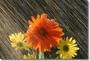
Weather Topic: What is Precipitation?
Home - Education - Precipitation - Precipitation
 Next Topic: Rain
Precipitation can refer to many different forms of water that
may fall from clouds. Precipitation occurs after a cloud has become saturated to
the point where its water particles are more dense than the air below the cloud.
In most cases, precipitation will reach the ground, but it is not uncommon for
precipitation to evaporate before it reaches the earth's surface.
When precipitation evaporates before it contacts the ground it is called Virga.
Graupel, hail, sleet, rain, drizzle, and snow are forms of precipitation, but fog
and mist are not considered precipitation because the water vapor which
constitutes them isn't dense enough to fall to the ground.
Next Topic: Rain
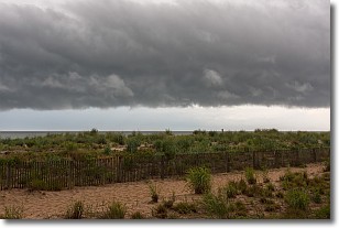
Weather Topic: What are Shelf Clouds?
Home - Education - Cloud Types - Shelf Clouds
 Next Topic: Sleet
A shelf cloud is similar to a wall cloud, but forms at the front
of a storm cloud, instead of at the rear, where wall clouds form.
A shelf cloud is caused by a series of events set into motion by the advancing
storm; first, cool air settles along the ground where precipitation has just fallen.
As the cool air is brought in, the warmer air is displaced, and rises above it,
because it is less dense. When the warmer air reaches the bottom of the storm cloud,
it begins to cool again, and the resulting condensation is a visible shelf cloud.
Next Topic: Sleet
Current conditions powered by WeatherAPI.com


