Weather Alert in Texas
Special Weather Statement issued September 5 at 6:35PM CDT by NWS Fort Worth TX
AREAS AFFECTED: Denton; Collin; Tarrant; Dallas
DESCRIPTION: At 634 PM CDT, Doppler radar was tracking an outflow boundary with strong winds along a line extending from Highland Village to Flower Mound to Keller to Eagle Mountain. Movement was east at 30 mph. HAZARD...Winds in excess of 30 mph. SOURCE...Radar indicated. IMPACT...Gusty winds could knock down tree limbs and blow around unsecured objects. Strong thunderstorms will be near... Fort Worth, Irving, Carrollton, Lewisville, Flower Mound, Euless, Bedford, Grapevine, Haltom City, and Keller around 640 PM CDT. Richland Hills around 645 PM CDT. Other locations impacted by these storms include Westlake, Lewisville Lake, Lake Worth, Lakeside, Westover Hills, Lakewood Village, Grapevine Lake, and Oak Point. This includes the following highways... Interstate 35W between mile markers 49 and 63. Interstate 35E between mile markers 437 and 459. Interstate 20 between mile markers 423 and 427. Interstate 30 between mile markers 2 and 23.
INSTRUCTION: If outdoors, consider seeking shelter inside a building.
Want more detail? Get the Complete 7 Day and Night Detailed Forecast!
Current U.S. National Radar--Current
The Current National Weather Radar is shown below with a UTC Time (subtract 5 hours from UTC to get Eastern Time).

National Weather Forecast--Current
The Current National Weather Forecast and National Weather Map are shown below.

National Weather Forecast for Tomorrow
Tomorrow National Weather Forecast and Tomorrow National Weather Map are show below.

North America Water Vapor (Moisture)
This map shows recent moisture content over North America. Bright and colored areas show high moisture (ie, clouds); brown indicates very little moisture present; black indicates no moisture.

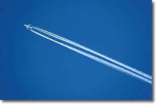
Weather Topic: What are Contrails?
Home - Education - Cloud Types - Contrails
 Next Topic: Cumulonimbus Clouds
A contrail is an artificial cloud, created by the passing of an
aircraft.
Contrails form because water vapor in the exhaust of aircraft engines is suspended
in the air under certain temperatures and humidity conditions. These contrails
are called exhaust contrails.
Another type of contrail can form due to a temporary reduction in air pressure
moving over the plane's surface, causing condensation.
These are called aerodynamic contrails.
When you can see your breath on a cold day, it is also because of condensation.
The reason contrails last longer than the condensation from your breath is
because the water in contrails freezes into ice particles.
Next Topic: Cumulonimbus Clouds
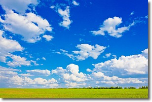
Weather Topic: What are Cumulus Clouds?
Home - Education - Cloud Types - Cumulus Clouds
 Next Topic: Drizzle
Cumulus clouds are fluffy and textured with rounded tops, and
may have flat bottoms. The border of a cumulus cloud
is clearly defined, and can have the appearance of cotton or cauliflower.
Cumulus clouds form at low altitudes (rarely above 2 km) but can grow very tall,
becoming cumulus congestus and possibly the even taller cumulonimbus clouds.
When cumulus clouds become taller, they have a greater chance of producing precipitation.
Next Topic: Drizzle
Current conditions powered by WeatherAPI.com


