Weather Alert in Arizona
Flood Advisory issued September 3 at 1:19PM MST until September 3 at 4:15PM MST by NWS Flagstaff AZ
AREAS AFFECTED: Coconino, AZ
DESCRIPTION: * WHAT...Flooding caused by excessive rainfall is expected along Lake Mary Road, near Mormon Lake. * WHERE...A portion of north central Arizona, including the following county, Coconino. * WHEN...Until 415 PM MST. * IMPACTS...Minor flooding in creeks and normally dry washes is imminent or occurring. * ADDITIONAL DETAILS... - At 117 PM MST, Doppler radar indicated heavy rain due to thunderstorms. Minor flooding is ongoing or expected to begin shortly in the advisory area. - This includes the following creeks, washes and rivers... Youngs Canyon, Yellow Jacket Canyon, Anderson Canyon, Padre Canyon, Yaeger Canyon and Walnut Creek. - Some locations that will experience flooding include... Ashurst Lake, Perry Lake, Boot Lake, Mud Lake, Lakeview, Mormon Lake and Upper Lake Mary. - This includes the following recreation areas and campgrounds... Dairy Springs Campground, Ashurst Lake Campgrounds, Pine Grove Campground, Forked Pine Campground and Dairy Springs Campground. - Additional information is available at weather.gov/flagstaff.
INSTRUCTION: Be aware of your surroundings and do not drive on flooded roads. Low water crossings will become dangerous in heavy rain. Do not attempt to cross flooded roads. Find an alternate route.
Want more detail? Get the Complete 7 Day and Night Detailed Forecast!
Current U.S. National Radar--Current
The Current National Weather Radar is shown below with a UTC Time (subtract 5 hours from UTC to get Eastern Time).

National Weather Forecast--Current
The Current National Weather Forecast and National Weather Map are shown below.

National Weather Forecast for Tomorrow
Tomorrow National Weather Forecast and Tomorrow National Weather Map are show below.

North America Water Vapor (Moisture)
This map shows recent moisture content over North America. Bright and colored areas show high moisture (ie, clouds); brown indicates very little moisture present; black indicates no moisture.

Weather Topic: What is Snow?
Home - Education - Precipitation - Snow
 Next Topic: Stratocumulus Clouds
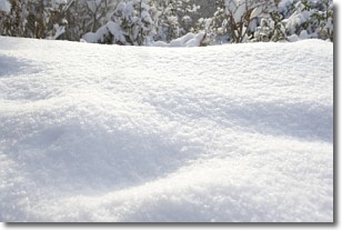
Snow is precipitation taking the form of ice crystals. Each ice crystal, or snowflake,
has unique characteristics, but all of them grow in a hexagonal structure.
Snowfall can last for sustained periods of time and result in significant buildup
of snow on the ground.
On the earth's surface, snow starts out light and powdery, but as it begins to melt
it tends to become more granular, producing small bits of ice which have the consistency of
sand. After several cycles of melting and freezing, snow can become very dense
and ice-like, commonly known as snow pack.
Next Topic: Stratocumulus Clouds
Weather Topic: What are Stratus Clouds?
Home - Education - Cloud Types - Stratus Clouds
 Next Topic: Wall Clouds
Stratus clouds are similar to altostratus clouds, but form at a
lower altitude and are identified by their fog-like appearance, lacking the
distinguishing features of most clouds.
Stratus clouds are wider than most clouds, and their base has a smooth, uniform
look which is lighter in color than a nimbostratus cloud.
The presence of a stratus cloud indicates the possibility of minor precipitation,
such as drizzle, but heavier precipitation does not typically arrive in the form
of a stratus cloud.
Next Topic: Wall Clouds
Current conditions powered by WeatherAPI.com


