Weather Alert in California
Winter Weather Advisory issued February 7 at 11:07AM PST until February 11 at 4:00PM PST by NWS Reno NV
AREAS AFFECTED: Greater Lake Tahoe Area; Greater Lake Tahoe Area
DESCRIPTION: * WHAT...Snow. Snow accumulations of 10 to 18 inches above 7000 feet. At Lake Tahoe level, 4 to 6 inches, with 6 to 12 inches along and west of Highway 89. Wind gusts up to 35 mph, with gusts reaching 70 mph along the Sierra crest. Wave heights 1 to 3 feet on Lake Tahoe. * WHERE...Greater Lake Tahoe Area. * WHEN...From 10 PM Monday to 4 PM PST Wednesday. * IMPACTS...Travel could be very difficult. The hazardous conditions could impact the Tuesday morning and evening commutes. Gusty winds could bring down tree branches. Small boats, kayaks and paddle boards will be prone to capsizing and should remain off lake waters until conditions improve.
INSTRUCTION: Slow down and use caution while traveling. Keep an extra flashlight, food, and water in your vehicle in case of an emergency. The latest road conditions for the state you are calling from can be obtained by calling 5 1 1.
Want more detail? Get the Complete 7 Day and Night Detailed Forecast!
Current U.S. National Radar--Current
The Current National Weather Radar is shown below with a UTC Time (subtract 5 hours from UTC to get Eastern Time).

National Weather Forecast--Current
The Current National Weather Forecast and National Weather Map are shown below.

National Weather Forecast for Tomorrow
Tomorrow National Weather Forecast and Tomorrow National Weather Map are show below.

North America Water Vapor (Moisture)
This map shows recent moisture content over North America. Bright and colored areas show high moisture (ie, clouds); brown indicates very little moisture present; black indicates no moisture.

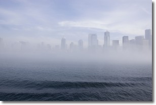
Weather Topic: What is Fog?
Home - Education - Cloud Types - Fog
 Next Topic: Fractus Clouds
Fog is technically a type of stratus cloud, which lies along the
ground and obscures visibility.
It is usually created when humidity in the air condenses into tiny water droplets.
Because of this, some places are more prone to foggy weather, such as regions
close to a body of water.
Fog is similar to mist; both are the appearance of water droplets suspended in
the air, but fog is the term applied to the condition when visibility is less than 1 km.
Next Topic: Fractus Clouds
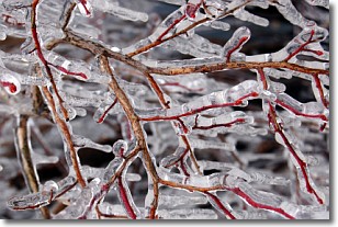
Weather Topic: What is Freezing Rain?
Home - Education - Precipitation - Freezing Rain
 Next Topic: Graupel
Freezing rain is a condition where precipitation which has fallen in the form of
water droplets reaches temperatures which are below freezing and freezes upon
coming into contact
with surface objects. The result of this precipitation is a glaze of ice which
can be damaging to plants and man-made structures. A severe onset of freezing
rain which results in a very thick glaze of ice is known as an ice storm.
Next Topic: Graupel
Current conditions powered by WeatherAPI.com


