Weather Alert in California
High Surf Advisory High Wind Warning Wind Advisory Winter Storm Watch
Avalanche Watch issued February 15 at 7:10AM PST by NWS Reno NV
AREAS AFFECTED: Mono
DESCRIPTION: AVAREV The following message is transmitted at the request of the Eastern Sierra Avalanche Center. The Eastern Sierra Avalanche Center in Mammoth Lakes has issued a BACKCOUNTRY AVALANCHE WATCH for the following areas: NWS Las Vegas NV - CA-519 (Eastern Sierra in Inyo County) NWS Reno NV - CA-073 (Eastern Sierra in Mono County) * WHAT...The avalanche danger is expected to rise to HIGH by Monday afternoon (February 16) and remain elevated through mid- week. * WHERE...The eastern Sierra Nevada from Virginia Lakes to the southern end of Bishop Creek. * WHEN...In effect from Monday 7 AM PST to Tuesday 7 AM PST. * IMPACTS...Heavy snow and extreme winds will create widespread areas of unstable snow. * PRECAUTIONARY / PREPAREDNESS ACTIONS...Very dangerous avalanche conditions are expected to develop. Avalanches may run long distances, into mature forests, valley floors, or flat terrain. Travel in avalanche terrain is not recommended. Consult http://www.esavalanche.org/ or www.avalanche.org for more detailed information. Similar avalanche danger may exist at locations outside the coverage area of this or any avalanche center.
INSTRUCTION: N/A
Want more detail? Get the Complete 7 Day and Night Detailed Forecast!
Current U.S. National Radar--Current
The Current National Weather Radar is shown below with a UTC Time (subtract 5 hours from UTC to get Eastern Time).

National Weather Forecast--Current
The Current National Weather Forecast and National Weather Map are shown below.

National Weather Forecast for Tomorrow
Tomorrow National Weather Forecast and Tomorrow National Weather Map are show below.

North America Water Vapor (Moisture)
This map shows recent moisture content over North America. Bright and colored areas show high moisture (ie, clouds); brown indicates very little moisture present; black indicates no moisture.

Weather Topic: What is Condensation?
Home - Education - Precipitation - Condensation
 Next Topic: Contrails
Condensation is the process which creates clouds, and therefore
it is a crucial process in the water cycle.
Condensation is the change of matter from a state of gas into a state of liquid,
and it happens because water molecules release heat into the atmosphere and
become organized into a more closely packed structure, what we might see as
water droplets.
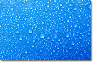
Water is always present in the air around us as a vapor, but it's too small for
us to see. When water undergoes the process of condensation it becomes organized
into visible water droplets. You've probably seen condensation happen before on the
surface of a cold drink!
Next Topic: Contrails
Weather Topic: What are Cumulonimbus Clouds?
Home - Education - Cloud Types - Cumulonimbus Clouds
 Next Topic: Cumulus Clouds
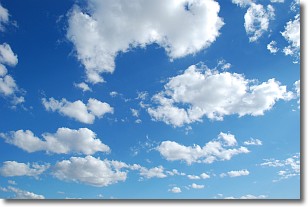
The final form taken by a growing cumulus cloud is the
cumulonimbus cloud, which is very tall and dense.
The tower of a cumulonimbus cloud can soar 23 km into the atmosphere, although
most commonly they stop growing at an altitude of 6 km.
Even small cumulonimbus clouds appear very large in comparison to other cloud types.
They can signal the approach of stormy weather, such as thunderstorms or blizzards.
Next Topic: Cumulus Clouds
Current conditions powered by WeatherAPI.com


