Weather Alert in Minnesota
Winter Storm Warning issued February 16 at 10:17PM CST until February 19 at 12:00PM CST by NWS Duluth MN
AREAS AFFECTED: Northern Cook/Northern Lake
DESCRIPTION: * WHAT...Heavy snow expected. Total snow accumulations between 4 and 8 inches except between 10 and 15 inches for the higher terrain of the North Shore. Winds gusting as high as 50 mph. * WHERE...Northern Cook and Lake County. This also includes the Boundary Waters eastern and central area. * WHEN...From 9 PM Tuesday to noon CST Thursday. * IMPACTS...Near whiteout conditions are possible as visibilities may drop to around 1/4 mile due to falling and blowing snow. * ADDITIONAL DETAILS...Expect terrain enhancement to snowfall totals and snowfall rates along the North Shore terrain ridge parts of central Lake County. The heaviest snowfall rates will be Tuesday night and Wednesday morning.
INSTRUCTION: If you must travel, keep an extra flashlight, food, and water in your vehicle in case of an emergency. Call 511 or visit www.511mn.org for Minnesota road information.
Want more detail? Get the Complete 7 Day and Night Detailed Forecast!
Current U.S. National Radar--Current
The Current National Weather Radar is shown below with a UTC Time (subtract 5 hours from UTC to get Eastern Time).

National Weather Forecast--Current
The Current National Weather Forecast and National Weather Map are shown below.

National Weather Forecast for Tomorrow
Tomorrow National Weather Forecast and Tomorrow National Weather Map are show below.

North America Water Vapor (Moisture)
This map shows recent moisture content over North America. Bright and colored areas show high moisture (ie, clouds); brown indicates very little moisture present; black indicates no moisture.

Weather Topic: What is Graupel?
Home - Education - Precipitation - Graupel
 Next Topic: Hail
Graupel is a form of precipitation that is created by atmospheric conditions
which cause supercooled water droplets to contact snow crystals and freeze to
their surface.
Sometimes known as soft hail or snow pellets, graupel is delicate and easily
destroyed by touch. Whereas hail usually falls during severe weather, graupel
doesn't require such conditions to form, and can form in mild precipitation
similar to situations which produce snowfall.
Next Topic: Hail
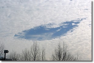
Weather Topic: What are Hole Punch Clouds?
Home - Education - Cloud Types - Hole Punch Clouds
 Next Topic: Mammatus Clouds
A hole punch cloud is an unusual occurrence when a disk-shaped
hole appears in a cirrostratus, cirrocumulus, or altocumulus cloud.
When part of the cloud forms ice crystals, water droplets in the surrounding area
of the cloud evaporate. The effect of this process produces a large elliptical
gap in the cloud. The hole punch cloud formation is rare, but it is not specific
to any geographic area.
Other names which have been used to describe this phenomena include fallstreak hole,
skypunch, and cloud hole.
Next Topic: Mammatus Clouds
Current conditions powered by WeatherAPI.com


