Weather Alert in Utah
Winter Storm Warning issued February 16 at 4:04AM MST until February 19 at 5:00AM MST by NWS Salt Lake City UT
AREAS AFFECTED: Wasatch Back; Wasatch Mountains I-80 North; Wasatch Mountains South of I-80; Western Uinta Mountains
DESCRIPTION: * WHAT...Heavy snow expected. Total snow accumulations between 1 and 2 feet with locally higher accumulations up to 3 feet across the Upper Cottonwoods and Bear River Mountains. * WHERE...The Wasatch Mountains, Western Uinta Mountains, and the Wasatch Back, including areas near Park City. * WHEN...From 5 PM this afternoon to 5 AM MST Thursday. * IMPACTS...Winter driving conditions can be expected on all mountain routes. Traction restrictions are likely. * ADDITIONAL DETAILS...A period of heavy snow is expected Monday night, with snowfall continuing into Tuesday afternoon. A brief lull is expected Tuesday afternoon before ramping up again Tuesday evening. Another round of heavy snow is expected mid-day Wednesday. Very strong winds, peaking Monday evening, will persist through at least Wednesday.
INSTRUCTION: If you must travel, keep an extra flashlight, food, and water in your vehicle in case of an emergency. For winter road conditions from the Utah Department of Transportation, visit http://www.udottraffic.utah.gov. For graphical depictions of the snowfall forecast, including Official NWS Forecast, High End Amount, and Low End Amount, visit weather.gov/slc/winter.
Want more detail? Get the Complete 7 Day and Night Detailed Forecast!
Current U.S. National Radar--Current
The Current National Weather Radar is shown below with a UTC Time (subtract 5 hours from UTC to get Eastern Time).

National Weather Forecast--Current
The Current National Weather Forecast and National Weather Map are shown below.

National Weather Forecast for Tomorrow
Tomorrow National Weather Forecast and Tomorrow National Weather Map are show below.

North America Water Vapor (Moisture)
This map shows recent moisture content over North America. Bright and colored areas show high moisture (ie, clouds); brown indicates very little moisture present; black indicates no moisture.

Weather Topic: What are Cirrocumulus Clouds?
Home - Education - Cloud Types - Cirrocumulus Clouds
 Next Topic: Cirrostratus Clouds
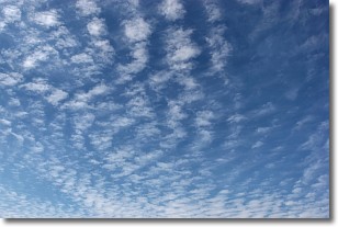
Cirrocumulus clouds form at high altitudes (usually around 5 km)
and have distinguishing characteristics displayed in a fine layer of
small cloud patches. These small cloud patches are sometimes referred to as
"cloudlets" in relation to the whole cloud formation.
Cirrocumulus clouds are formed from ice crystals and water droplets. Often, the
water droplets in the cloud freeze into ice crystals and the cloud becomes a
cirrostratus cloud. Because of this common occurrence, cirrocumulus cloud
formations generally pass rapidly.
Next Topic: Cirrostratus Clouds
Weather Topic: What are Cirrus Clouds?
Home - Education - Cloud Types - Cirrus Clouds
 Next Topic: Condensation
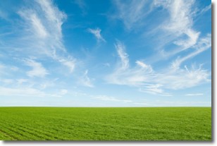
Cirrus clouds are high-level clouds that occur above 20,000 feet
and are composed mainly of ice crystals.
They are thin and wispy in appearance.
What do they indicate?
They are often the first sign of an approaching storm.
Next Topic: Condensation
Current conditions powered by WeatherAPI.com


