Weather Alert in Colorado
High Wind Watch issued February 15 at 11:10PM MST until February 17 at 5:00PM MST by NWS Denver CO
AREAS AFFECTED: North and Northeast Elbert County Below 6000 Feet/North Lincoln County; Southeast Elbert County Below 6000 Feet/South Lincoln County; Washington County
DESCRIPTION: * WHAT...West winds 30 to 40 mph with gusts up to 65 mph possible. * WHERE...Limon, Southern Lincoln County, and Akron. * WHEN...From Tuesday morning through Tuesday afternoon. * IMPACTS...Gusty winds will blow around unsecured objects and a few power outages may result. Strong winds will likely lead to rapid fire growth of any new fire. Blowing dust will reduce visibility to less than a quarter mile in places.
INSTRUCTION: Fasten loose objects or shelter objects in a safe location prior to the onset of winds. Winds this strong can make driving difficult, especially for high profile vehicles. Use extra caution. Avoid outdoor burning or any activity that may cause sparks. The strong winds will likely fuel rapid fire growth.
Want more detail? Get the Complete 7 Day and Night Detailed Forecast!
Current U.S. National Radar--Current
The Current National Weather Radar is shown below with a UTC Time (subtract 5 hours from UTC to get Eastern Time).

National Weather Forecast--Current
The Current National Weather Forecast and National Weather Map are shown below.

National Weather Forecast for Tomorrow
Tomorrow National Weather Forecast and Tomorrow National Weather Map are show below.

North America Water Vapor (Moisture)
This map shows recent moisture content over North America. Bright and colored areas show high moisture (ie, clouds); brown indicates very little moisture present; black indicates no moisture.

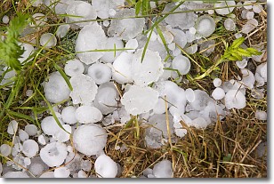
Weather Topic: What is Hail?
Home - Education - Precipitation - Hail
 Next Topic: Hole Punch Clouds
Hail is a form of precipitation which is recognized by large solid balls or
clumps of ice. Hail is created by thunderstorm clouds with strong updrafts of wind.
As the hailstones remain in the updraft, ice is deposited onto them until their
weight becomes heavy enough for them to fall to the earth's surface.
Hail storms can cause significant damage to crops, aircrafts, and man-made structures,
despite the fact that the duration is usually less than ten minutes.
Next Topic: Hole Punch Clouds
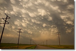
Weather Topic: What are Mammatus Clouds?
Home - Education - Cloud Types - Mammatus Clouds
 Next Topic: Nimbostratus Clouds
A mammatus cloud is a cloud with a unique feature which resembles
a web of pouches hanging along the base of the cloud.
In the United States, mammatus clouds tend to form in the warmer months, commonly
in the Midwest and eastern regions.
While they usually form at the bottom of a cumulonimbis cloud, they can also form
under altostratus, altocumulus, stratocumulus, and cirrus clouds. Mammatus clouds
warn that severe weather is close.
Next Topic: Nimbostratus Clouds
Current conditions powered by WeatherAPI.com


