Weather Alert in South Dakota
High Wind Warning issued February 16 at 9:05PM MST until February 17 at 6:00PM MST by NWS Rapid City SD
AREAS AFFECTED: Southern Foothills; Southern Black Hills; Western Fall River; Eastern Fall River; Northern Campbell; Southern Campbell; Weston County Plains; Newcastle
DESCRIPTION: * WHAT...West winds 30 to 40 mph with gusts up to 65 mph expected. * WHERE...In South Dakota, Eastern Fall River, Southern Foothills, Western Fall River, and Southern Black Hills. In Wyoming, Newcastle, Northern Campbell, Southern Campbell, and Weston County Plains. * WHEN...From 9 AM to 6 PM MST Tuesday. * IMPACTS...The high winds may damage roofs, small outbuildings, and signs. Power outages are possible. Travel could be difficult, especially for high profile vehicles. Strong winds can cause blowing dust, reduced visibility, and flying debris.
INSTRUCTION: A high wind warning means 40 mph winds, or gusts over 60 mph, are expected or occurring. If you are outdoors, watch for flying or falling objects that may injure you. Use caution if you must drive.
Want more detail? Get the Complete 7 Day and Night Detailed Forecast!
Current U.S. National Radar--Current
The Current National Weather Radar is shown below with a UTC Time (subtract 5 hours from UTC to get Eastern Time).

National Weather Forecast--Current
The Current National Weather Forecast and National Weather Map are shown below.

National Weather Forecast for Tomorrow
Tomorrow National Weather Forecast and Tomorrow National Weather Map are show below.

North America Water Vapor (Moisture)
This map shows recent moisture content over North America. Bright and colored areas show high moisture (ie, clouds); brown indicates very little moisture present; black indicates no moisture.

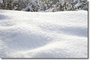
Weather Topic: What is Snow?
Home - Education - Precipitation - Snow
 Next Topic: Stratocumulus Clouds
Snow is precipitation taking the form of ice crystals. Each ice crystal, or snowflake,
has unique characteristics, but all of them grow in a hexagonal structure.
Snowfall can last for sustained periods of time and result in significant buildup
of snow on the ground.
On the earth's surface, snow starts out light and powdery, but as it begins to melt
it tends to become more granular, producing small bits of ice which have the consistency of
sand. After several cycles of melting and freezing, snow can become very dense
and ice-like, commonly known as snow pack.
Next Topic: Stratocumulus Clouds
Weather Topic: What are Stratus Clouds?
Home - Education - Cloud Types - Stratus Clouds
 Next Topic: Wall Clouds
Stratus clouds are similar to altostratus clouds, but form at a
lower altitude and are identified by their fog-like appearance, lacking the
distinguishing features of most clouds.
Stratus clouds are wider than most clouds, and their base has a smooth, uniform
look which is lighter in color than a nimbostratus cloud.
The presence of a stratus cloud indicates the possibility of minor precipitation,
such as drizzle, but heavier precipitation does not typically arrive in the form
of a stratus cloud.
Next Topic: Wall Clouds
Current conditions powered by WeatherAPI.com


