Weather Alert in Illinois
Flood Warning issued April 4 at 2:30PM CDT until April 5 at 10:00AM CDT by NWS Chicago IL
AREAS AFFECTED: Boone, IL; Winnebago, IL
DESCRIPTION: ...The National Weather Service in Chicago IL has issued a Flood Warning for the following rivers in Illinois... Kishwaukee River at Belvidere affecting Winnebago and Boone Counties. For the Kishwaukee River...including Belvidere...Minor flooding is forecast. * WHAT...Minor flooding is forecast. * WHERE...Kishwaukee River from County Line Road downstream to confluence with South Branch Kishwaukee River, including the Belvidere gauge. * WHEN...Until late tomorrow morning. * IMPACTS...At 9.0 feet, Boone-McHenry County Line Road threatened. Low-lying areas are threatened in Belvidere Park. * ADDITIONAL DETAILS... - At 1:30 PM CDT Saturday the stage was 8.9 feet. - Forecast...The river is expected to rise above flood stage this afternoon to a crest of 9.1 feet this evening. It will then fall below flood stage late tonight. - Flood stage is 9.0 feet. - http://www.weather.gov/safety/flood
INSTRUCTION: A Flood Warning means water levels above flood stage are imminent or may already be occurring. Persons along rivers and streams in the warned area should take immediate precautions to protect life and property. These forecasts are based on observed precipitation as well as forecast precipitation 24 hours into the future. Changes to the rainfall forecast, or any additional rainfall after 24 hours, may cause changes to these river forecasts. Additional information is available at www.weather.gov. The next statement will be issued by Sunday morning.
Want more detail? Get the Complete 7 Day and Night Detailed Forecast!
Current U.S. National Radar--Current
The Current National Weather Radar is shown below with a UTC Time (subtract 5 hours from UTC to get Eastern Time).

National Weather Forecast--Current
The Current National Weather Forecast and National Weather Map are shown below.

National Weather Forecast for Tomorrow
Tomorrow National Weather Forecast and Tomorrow National Weather Map are show below.

North America Water Vapor (Moisture)
This map shows recent moisture content over North America. Bright and colored areas show high moisture (ie, clouds); brown indicates very little moisture present; black indicates no moisture.

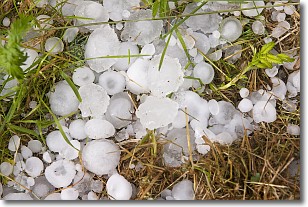
Weather Topic: What is Hail?
Home - Education - Precipitation - Hail
 Next Topic: Hole Punch Clouds
Hail is a form of precipitation which is recognized by large solid balls or
clumps of ice. Hail is created by thunderstorm clouds with strong updrafts of wind.
As the hailstones remain in the updraft, ice is deposited onto them until their
weight becomes heavy enough for them to fall to the earth's surface.
Hail storms can cause significant damage to crops, aircrafts, and man-made structures,
despite the fact that the duration is usually less than ten minutes.
Next Topic: Hole Punch Clouds
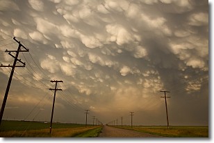
Weather Topic: What are Mammatus Clouds?
Home - Education - Cloud Types - Mammatus Clouds
 Next Topic: Nimbostratus Clouds
A mammatus cloud is a cloud with a unique feature which resembles
a web of pouches hanging along the base of the cloud.
In the United States, mammatus clouds tend to form in the warmer months, commonly
in the Midwest and eastern regions.
While they usually form at the bottom of a cumulonimbis cloud, they can also form
under altostratus, altocumulus, stratocumulus, and cirrus clouds. Mammatus clouds
warn that severe weather is close.
Next Topic: Nimbostratus Clouds
Current conditions powered by WeatherAPI.com


