Weather Alert in California
Avalanche Watch issued February 15 at 7:36AM PST by NWS Las Vegas NV
AREAS AFFECTED: Eastern Sierra Slopes of Inyo County
DESCRIPTION: AVAVEF The Eastern Sierra Avalanche Center in Mammoth Lakes has issued a Backcountry Avalanche Watch for the following areas: the Eastern Sierra in Mono County and the Eastern Sierra in Inyo County * WHAT...The avalanche danger is expected to rise to HIGH by tomorrow afternoon and remain elevated into mid-week. * WHERE...The eastern slopes of the Sierra Nevada mountain range between Virgina Lakes on the north to Bishop Creek on the south. * WHEN...In effect from Sun 07:00 PST to Mon 07:00 PST. * IMPACTS...|Heavy snow and extreme winds will create widespread areas of unstable snow.
INSTRUCTION: Very dangerous avalanche conditions are expected to develop. Avalanches may run long distances, and can run into mature forests, valley floors or flat terrain. Travel in avalanche terrain is not recommended. Consult http://www.esavalanche.org or www.avalanche.org for more detailed information Similar avalanche danger may exist at locations outside the coverage area of this or any avalanche center.
Want more detail? Get the Complete 7 Day and Night Detailed Forecast!
Current U.S. National Radar--Current
The Current National Weather Radar is shown below with a UTC Time (subtract 5 hours from UTC to get Eastern Time).

National Weather Forecast--Current
The Current National Weather Forecast and National Weather Map are shown below.

National Weather Forecast for Tomorrow
Tomorrow National Weather Forecast and Tomorrow National Weather Map are show below.

North America Water Vapor (Moisture)
This map shows recent moisture content over North America. Bright and colored areas show high moisture (ie, clouds); brown indicates very little moisture present; black indicates no moisture.

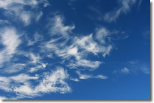
Weather Topic: What are Cirrostratus Clouds?
Home - Education - Cloud Types - Cirrostratus Clouds
 Next Topic: Cirrus Clouds
Cirrostratus clouds are high, thin clouds that form above
20,000 feet and are made mostly of ice crystals. They sometimes look like giant
feathers, horse tails, or curls of hair in the sky.
These clouds are pushed by the jet stream and can move at high speeds reaching
100 mph.
What do they indicate?
They indicate that a precipitation is likely within 24 hours.
Next Topic: Cirrus Clouds
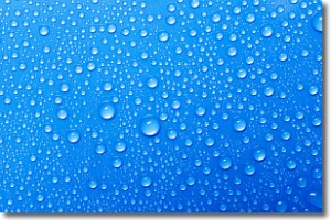
Weather Topic: What is Condensation?
Home - Education - Precipitation - Condensation
 Next Topic: Contrails
Condensation is the process which creates clouds, and therefore
it is a crucial process in the water cycle.
Condensation is the change of matter from a state of gas into a state of liquid,
and it happens because water molecules release heat into the atmosphere and
become organized into a more closely packed structure, what we might see as
water droplets.
Water is always present in the air around us as a vapor, but it's too small for
us to see. When water undergoes the process of condensation it becomes organized
into visible water droplets. You've probably seen condensation happen before on the
surface of a cold drink!
Next Topic: Contrails
Current conditions powered by WeatherAPI.com


