Weather Alert in South Dakota
Red Flag Warning issued February 16 at 4:51PM MST until February 17 at 6:00PM MST by NWS Rapid City SD
AREAS AFFECTED: Northern Foot Hills; Butte County Area; Northern Campbell; Crook County Plains
DESCRIPTION: ...CRITICAL FIRE WEATHER CONDITIONS TUESDAY... .Very dry air will spread across the region Tuesday, with RH's expected into the mid teens to lower 20s. In addition, strong gusty westerly winds will develop with some areas seeing gusts over 60 mph, especially portions of northeast WY and far southwest SD. The combination of receptive fuels, strong gusty winds, and very low RH will support critical fire weather conditions. The National Weather Service in Rapid City has issued a Red Flag Warning for gusty winds and low relative humidity, which is in effect from 11 AM to 6 PM MST Tuesday. * AFFECTED AREA...Fire Weather Zones 314 Northern Campbell, 316 Crook County Plains, 323 Northern Foot Hills and 327 Butte County Area. * WINDS...West 25 to 35 mph with gusts up to 55 mph. * RELATIVE HUMIDITY...As low as 20 percent. * IMPACTS...The combination of gusty winds and low relative humidity will produce critical fire weather conditions.
INSTRUCTION: A Red Flag Warning means that critical fire weather conditions are either occurring now, or will shortly. A combination of strong winds, low relative humidity, and warm temperatures can contribute to extreme fire behavior.
Want more detail? Get the Complete 7 Day and Night Detailed Forecast!
Current U.S. National Radar--Current
The Current National Weather Radar is shown below with a UTC Time (subtract 5 hours from UTC to get Eastern Time).

National Weather Forecast--Current
The Current National Weather Forecast and National Weather Map are shown below.

National Weather Forecast for Tomorrow
Tomorrow National Weather Forecast and Tomorrow National Weather Map are show below.

North America Water Vapor (Moisture)
This map shows recent moisture content over North America. Bright and colored areas show high moisture (ie, clouds); brown indicates very little moisture present; black indicates no moisture.

Weather Topic: What is Graupel?
Home - Education - Precipitation - Graupel
 Next Topic: Hail
Graupel is a form of precipitation that is created by atmospheric conditions
which cause supercooled water droplets to contact snow crystals and freeze to
their surface.
Sometimes known as soft hail or snow pellets, graupel is delicate and easily
destroyed by touch. Whereas hail usually falls during severe weather, graupel
doesn't require such conditions to form, and can form in mild precipitation
similar to situations which produce snowfall.
Next Topic: Hail
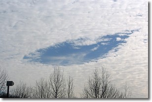
Weather Topic: What are Hole Punch Clouds?
Home - Education - Cloud Types - Hole Punch Clouds
 Next Topic: Mammatus Clouds
A hole punch cloud is an unusual occurrence when a disk-shaped
hole appears in a cirrostratus, cirrocumulus, or altocumulus cloud.
When part of the cloud forms ice crystals, water droplets in the surrounding area
of the cloud evaporate. The effect of this process produces a large elliptical
gap in the cloud. The hole punch cloud formation is rare, but it is not specific
to any geographic area.
Other names which have been used to describe this phenomena include fallstreak hole,
skypunch, and cloud hole.
Next Topic: Mammatus Clouds
Current conditions powered by WeatherAPI.com


