Weather Alert in New Mexico
Red Flag Warning issued February 9 at 1:01AM MST until February 9 at 6:00PM MST by NWS Albuquerque NM
AREAS AFFECTED: Northeast Plains; Northeast Highlands; Central Highlands; East Central Plains
DESCRIPTION: ...RED FLAG WARNING IN EFFECT FROM 11 AM TO 6 PM MST ACROSS EAST CENTRAL NEW MEXICO DUE TO STRONG WINDS AND LOW HUMIDITY... ..Stronger winds will develop today with very dry air also moving in. This will create critical fire weather and a higher risk for rapid fire spread. The National Weather Service in Albuquerque has issued a Red Flag Warning...which is in effect from 11 AM this morning to 6 PM MST this evening. The Fire Weather Watch is no longer in effect. * AREA AND TIMING...This includes much of northeastern and east central New Mexico (Fire Weather Zones 104, 123, 125, and 126) with the greatest area of concern focused in San Miguel, Guadalupe, Quay, and Curry counties. The warning is in effect from 11 AM through 6 PM MST Monday. * 20 FOOT WINDS...Sustained from the west and southwest at 20 to 25 mph with occasional gusts up to 35 mph. * RELATIVE HUMIDITY...Falling to 7 to 13 percent in the late afternoon Monday. * IMPACTS...Any fires that develop will likely spread rapidly. Outdoor burning is not recommended.
INSTRUCTION: Please advise the appropriate officials or fire crews in the field of this Red Flag Warning.
Want more detail? Get the Complete 7 Day and Night Detailed Forecast!
Current U.S. National Radar--Current
The Current National Weather Radar is shown below with a UTC Time (subtract 5 hours from UTC to get Eastern Time).

National Weather Forecast--Current
The Current National Weather Forecast and National Weather Map are shown below.

National Weather Forecast for Tomorrow
Tomorrow National Weather Forecast and Tomorrow National Weather Map are show below.

North America Water Vapor (Moisture)
This map shows recent moisture content over North America. Bright and colored areas show high moisture (ie, clouds); brown indicates very little moisture present; black indicates no moisture.

Weather Topic: What are Cumulonimbus Clouds?
Home - Education - Cloud Types - Cumulonimbus Clouds
 Next Topic: Cumulus Clouds
The final form taken by a growing cumulus cloud is the
cumulonimbus cloud, which is very tall and dense.
The tower of a cumulonimbus cloud can soar 23 km into the atmosphere, although
most commonly they stop growing at an altitude of 6 km.
Even small cumulonimbus clouds appear very large in comparison to other cloud types.
They can signal the approach of stormy weather, such as thunderstorms or blizzards.
Next Topic: Cumulus Clouds
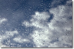
Weather Topic: What is Drizzle?
Home - Education - Precipitation - Drizzle
 Next Topic: Evaporation
Drizzle is precipitation in the form of water droplets which are
smaller than raindrops.
Drizzle is characterized by fine, gently falling droplets and typically does not
impact human habitation in a negative way. The exception to this is freezing drizzle,
a condition where drizzle freezes immediately upon reaching earth's surface.
Freezing drizzle is still less dangerous than freezing rain, but can
potentially result in hazardous road conditions.
Next Topic: Evaporation
Current conditions powered by WeatherAPI.com


