Weather Alert in New York
Cold Weather Advisory issued February 8 at 1:44AM EST until February 9 at 10:00AM EST by NWS Upton NY
AREAS AFFECTED: Northwest Suffolk; Southwest Suffolk; Northern Nassau; Southern Nassau
DESCRIPTION: * WHAT...For the Extreme Cold Warning, dangerously cold wind chills as low as 17 below. For the Cold Weather Advisory, very cold wind chills as low as 7 below expected. * WHERE...Northern Nassau, Northwest Suffolk, Southern Nassau, and Southwest Suffolk Counties. * WHEN...For the Extreme Cold Warning, until 1 PM EST this afternoon. For the Cold Weather Advisory, from 1 PM this afternoon to 10 AM EST Monday. * IMPACTS...The cold wind chills could result in hypothermia if precautions are not taken.
INSTRUCTION: Dress in layers including a hat, face mask, and gloves if you must go outside. Keep pets indoors as much as possible. Make frequent checks on older family, friends, and neighbors. Ensure portable heaters are used correctly. Do not use generators or grills inside.
Want more detail? Get the Complete 7 Day and Night Detailed Forecast!
Current U.S. National Radar--Current
The Current National Weather Radar is shown below with a UTC Time (subtract 5 hours from UTC to get Eastern Time).

National Weather Forecast--Current
The Current National Weather Forecast and National Weather Map are shown below.

National Weather Forecast for Tomorrow
Tomorrow National Weather Forecast and Tomorrow National Weather Map are show below.

North America Water Vapor (Moisture)
This map shows recent moisture content over North America. Bright and colored areas show high moisture (ie, clouds); brown indicates very little moisture present; black indicates no moisture.

Weather Topic: What are Altostratus Clouds?
Home - Education - Cloud Types - Altostratus Clouds
 Next Topic: Cirrocumulus Clouds
Altostratus clouds form at mid to high-level altitudes
(between 2 and 7 km) and are created by a warm, stable air mass which causes
water vapor
to condense as it rise through the atmosphere. Usually altostratus clouds are
featureless sheets characterized by a uniform color.
In some cases, wind punching through the cloud formation may give it a waved
appearance, called altostratus undulatus. Altostratus clouds
are commonly seen with other cloud formations accompanying them.
Next Topic: Cirrocumulus Clouds
Weather Topic: What are Cirrostratus Clouds?
Home - Education - Cloud Types - Cirrostratus Clouds
 Next Topic: Cirrus Clouds
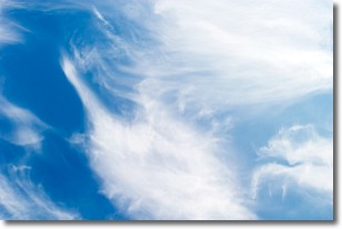
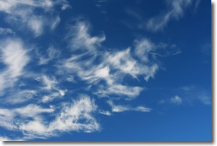
Cirrostratus clouds are high, thin clouds that form above
20,000 feet and are made mostly of ice crystals. They sometimes look like giant
feathers, horse tails, or curls of hair in the sky.
These clouds are pushed by the jet stream and can move at high speeds reaching
100 mph.
What do they indicate?
They indicate that a precipitation is likely within 24 hours.
Next Topic: Cirrus Clouds
Current conditions powered by WeatherAPI.com


