Weather Alert in Alaska
Winter Storm Watch issued February 28 at 5:49AM AKST until March 2 at 9:00AM AKST by NWS Juneau AK
AREAS AFFECTED: Petersburg Borough; City and Borough of Wrangell
DESCRIPTION: ...CENTRAL AND SOUTHERN PANHANDLE SNOW SATURDAY WITH POTENTIAL FOR MORE SNOW SUNDAY... Snowfall has increased in intensity and coverage overnight as a low tracks eastward across the Gulf towards the central panhandle. An estimated 2 to 4 inches has fallen overnight, these accumulations are separate from the next system set to affect the area through Saturday. Steady snowfall will continue through Saturday morning with rates increasing through the afternoon. Heaviest snowfall rates are expected to start by mid day along the coast, spreading eastward towards Hyder through Saturday night. As the low center tracks eastward through Saturday afternoon and evening, south to southwest wind will cause temperatures to warm over the southern outer coast with a mix or change to rain. Snow will then end on the NW side of the low, from Sitka to Juneau northward. Moisture will decrease overnight Saturday across the south, but then redevelop on Sunday as another system moves in. The rain/snow line will likely hover in vicinity of Sumner Strait Sunday into Monday with potential additional heavy snow for the Petersburg and Wrangell areas and lighter snow northward. A separate low pressure system looks to affect the region on Tuesday with potential for snow to push northward again. * WHAT...For the Winter Storm Warning, heavy snow expected. Total snow accumulations of 6 to 10 inches. For the Winter Storm Watch, heavy snow possible. Additional snow accumulations of 6 to 12 inches possible. * WHERE...Petersburg Borough and City and Borough of Wrangell. * WHEN...For the Winter Storm Warning, from 6 AM to 11 PM AKST Saturday. For the Winter Storm Watch, from Sunday morning through Monday morning. * IMPACTS...Travel will be difficult. * ADDITIONAL DETAILS...Heaviest snowfall rates on Saturday will be in the late afternoon and early evening.
INSTRUCTION: If you must travel, keep an extra flashlight, food, and water with you in case of an emergency. Monitor the latest forecasts for updates on this situation. People are urged to prepare their property before the onset of winter weather. For the latest road conditions, where available, call 5 1 1 or visit 511.alaska.gov.
Want more detail? Get the Complete 7 Day and Night Detailed Forecast!
Current U.S. National Radar--Current
The Current National Weather Radar is shown below with a UTC Time (subtract 5 hours from UTC to get Eastern Time).

National Weather Forecast--Current
The Current National Weather Forecast and National Weather Map are shown below.

National Weather Forecast for Tomorrow
Tomorrow National Weather Forecast and Tomorrow National Weather Map are show below.

North America Water Vapor (Moisture)
This map shows recent moisture content over North America. Bright and colored areas show high moisture (ie, clouds); brown indicates very little moisture present; black indicates no moisture.

Weather Topic: What are Cumulus Clouds?
Home - Education - Cloud Types - Cumulus Clouds
 Next Topic: Drizzle
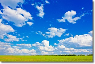
Cumulus clouds are fluffy and textured with rounded tops, and
may have flat bottoms. The border of a cumulus cloud
is clearly defined, and can have the appearance of cotton or cauliflower.
Cumulus clouds form at low altitudes (rarely above 2 km) but can grow very tall,
becoming cumulus congestus and possibly the even taller cumulonimbus clouds.
When cumulus clouds become taller, they have a greater chance of producing precipitation.
Next Topic: Drizzle
Weather Topic: What is Evaporation?
Home - Education - Precipitation - Evaporation
 Next Topic: Fog
Evaporation is the process which returns water from the earth
back to the atmosphere, and is another crucial process in the water cycle.
Evaporation is the transformation of liquid into gas, and it happens because
molecules are excited by the application of energy and turn into vapor.
In order for water to evaporate it has to be on the surface of a body of water.
Next Topic: Fog
Current conditions powered by WeatherAPI.com


