Weather Alert in Minnesota
Winter Storm Watch issued April 2 at 1:36PM CDT until April 5 at 1:00AM CDT by NWS Duluth MN
AREAS AFFECTED: Southern Lake/North Shore; Southern Cook/North Shore
DESCRIPTION: * WHAT...For the Winter Storm Warning, heavy snow. Additional snow accumulations between 4 and 6 inches. Winds gusting as high as 40 mph. For the Winter Storm Watch, heavy mixed precipitation possible. Total snow and sleet accumulations between 4 and 7 inches and ice accumulations around a light glaze possible. Winds could gust as high as 40 mph. * WHERE...Southern Cook and Southern Lake Counties. This includes the Tribal Lands of the Grand Portage Reservation. * WHEN...For the Winter Storm Warning, until 7 AM CDT Friday. For the Winter Storm Watch, from Friday afternoon through late Saturday night. * IMPACTS...Travel could be very difficult. The hazardous conditions could impact the Thursday evening and Friday morning commutes. * ADDITIONAL DETAILS...The majority of the snowfall is expected to fall during the daytime hours. With the high sun angle and temperatures hovering just above freezing, snowfall will have a difficult time accumulating on warm surfaces leading to a slushy mess.
INSTRUCTION: If you must travel, keep an extra flashlight, food, and water in your vehicle in case of an emergency. Call 511 or visit www.511mn.org for Minnesota road information. Monitor the latest forecasts for updates on this situation.
Want more detail? Get the Complete 7 Day and Night Detailed Forecast!
Current U.S. National Radar--Current
The Current National Weather Radar is shown below with a UTC Time (subtract 5 hours from UTC to get Eastern Time).

National Weather Forecast--Current
The Current National Weather Forecast and National Weather Map are shown below.

National Weather Forecast for Tomorrow
Tomorrow National Weather Forecast and Tomorrow National Weather Map are show below.

North America Water Vapor (Moisture)
This map shows recent moisture content over North America. Bright and colored areas show high moisture (ie, clouds); brown indicates very little moisture present; black indicates no moisture.

Weather Topic: What is Hail?
Home - Education - Precipitation - Hail
 Next Topic: Hole Punch Clouds
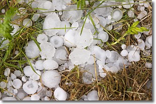
Hail is a form of precipitation which is recognized by large solid balls or
clumps of ice. Hail is created by thunderstorm clouds with strong updrafts of wind.
As the hailstones remain in the updraft, ice is deposited onto them until their
weight becomes heavy enough for them to fall to the earth's surface.
Hail storms can cause significant damage to crops, aircrafts, and man-made structures,
despite the fact that the duration is usually less than ten minutes.
Next Topic: Hole Punch Clouds
Weather Topic: What are Mammatus Clouds?
Home - Education - Cloud Types - Mammatus Clouds
 Next Topic: Nimbostratus Clouds
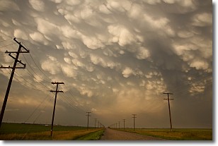
A mammatus cloud is a cloud with a unique feature which resembles
a web of pouches hanging along the base of the cloud.
In the United States, mammatus clouds tend to form in the warmer months, commonly
in the Midwest and eastern regions.
While they usually form at the bottom of a cumulonimbis cloud, they can also form
under altostratus, altocumulus, stratocumulus, and cirrus clouds. Mammatus clouds
warn that severe weather is close.
Next Topic: Nimbostratus Clouds
Current conditions powered by WeatherAPI.com


