Weather Alert in New York
Extreme Cold Warning issued February 8 at 12:37AM EST until February 8 at 1:00PM EST by NWS Binghamton NY
AREAS AFFECTED: Otsego; Delaware; Sullivan; Northern Wayne; Pike; Southern Wayne
DESCRIPTION: * WHAT...For the Extreme Cold Warning, dangerously cold wind chills as low as 30 below. For the Cold Weather Advisory, very cold wind chills as low as 20 below expected. * WHERE...In New York, Delaware, Otsego, and Sullivan Counties. In Pennsylvania, Northern Wayne, Pike, and Southern Wayne Counties. * WHEN...For the Extreme Cold Warning, until 1 PM EST this afternoon. For the Cold Weather Advisory, from 1 PM this afternoon to 10 AM EST Monday. * IMPACTS...The dangerously cold wind chills as low as 30 below zero could cause frostbite on exposed skin in as little as 15 minutes. Prolonged exposure to the cold may lead to hypothermia.
INSTRUCTION: Dress in layers including a hat, face mask, and gloves if you must go outside or travel. To prevent water pipes from freezing; wrap or drain or allow them to drip slowly. Keep pets indoors as much as possible.
Want more detail? Get the Complete 7 Day and Night Detailed Forecast!
Current U.S. National Radar--Current
The Current National Weather Radar is shown below with a UTC Time (subtract 5 hours from UTC to get Eastern Time).

National Weather Forecast--Current
The Current National Weather Forecast and National Weather Map are shown below.

National Weather Forecast for Tomorrow
Tomorrow National Weather Forecast and Tomorrow National Weather Map are show below.

North America Water Vapor (Moisture)
This map shows recent moisture content over North America. Bright and colored areas show high moisture (ie, clouds); brown indicates very little moisture present; black indicates no moisture.

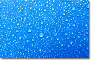
Weather Topic: What is Condensation?
Home - Education - Precipitation - Condensation
 Next Topic: Contrails
Condensation is the process which creates clouds, and therefore
it is a crucial process in the water cycle.
Condensation is the change of matter from a state of gas into a state of liquid,
and it happens because water molecules release heat into the atmosphere and
become organized into a more closely packed structure, what we might see as
water droplets.
Water is always present in the air around us as a vapor, but it's too small for
us to see. When water undergoes the process of condensation it becomes organized
into visible water droplets. You've probably seen condensation happen before on the
surface of a cold drink!
Next Topic: Contrails
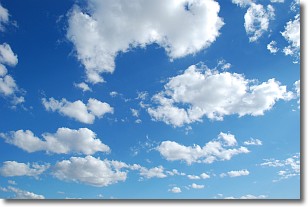
Weather Topic: What are Cumulonimbus Clouds?
Home - Education - Cloud Types - Cumulonimbus Clouds
 Next Topic: Cumulus Clouds
The final form taken by a growing cumulus cloud is the
cumulonimbus cloud, which is very tall and dense.
The tower of a cumulonimbus cloud can soar 23 km into the atmosphere, although
most commonly they stop growing at an altitude of 6 km.
Even small cumulonimbus clouds appear very large in comparison to other cloud types.
They can signal the approach of stormy weather, such as thunderstorms or blizzards.
Next Topic: Cumulus Clouds
Current conditions powered by WeatherAPI.com


