Weather Alert in Hawaii
Flood Watch issued February 7 at 3:41PM HST until February 9 at 6:00PM HST by NWS Honolulu HI
AREAS AFFECTED: Niihau; Kauai Southwest; Kauai Mountains; Waianae Coast; Oahu North Shore; Olomana; Central Oahu; Waianae Mountains; Lanai Mauka; Kahoolawe; Maui Windward West; Maui Leeward West; Haleakala Summit; Kona; Kohala; Big Island Interior; Kauai North; Kauai East; Kauai South; East Honolulu; Honolulu Metro; Ewa Plain; Koolau Windward; Koolau Leeward; Molokai Windward; Molokai Southeast; Molokai North; Molokai West; Molokai Leeward South; Lanai Windward; Lanai Leeward; Lanai South; Maui Central Valley North; Maui Central Valley South; Windward Haleakala; Kipahulu; South Maui/Upcountry; South Haleakala; Big Island South; Big Island Southeast; Big Island East; Big Island North
DESCRIPTION: ...FLOOD WATCH IN EFFECT FOR ALL HAWAIIAN ISLANDS THROUGH MONDAY AFTERNOON... * WHAT...Flash flooding caused by excessive rainfall continues to be possible. * WHERE...All the main Hawaiian islands. * WHEN...Through Monday afternoon. * IMPACTS...Flood prone roads and other low lying areas may be closed due to elevated runoff and overflowing streams. Urban areas may receive more significant flooding and property damage due to rapid runoff. * ADDITIONAL DETAILS... - A front will stall near Maui County through the weekend, allowing deep tropical moisture to pool over the island chain. This in combination with a disturbance aloft moving over the state, will bring the potential for heavy rainfall, a few thunderstorms and flash flooding beginning this afternoon and continuing through Monday afternoon. The greatest risk for flash flooding is expected in windward areas.
INSTRUCTION: You should monitor later forecasts and be prepared to take action should Flash Flood Warnings be issued.
Want more detail? Get the Complete 7 Day and Night Detailed Forecast!
Current U.S. National Radar--Current
The Current National Weather Radar is shown below with a UTC Time (subtract 5 hours from UTC to get Eastern Time).

National Weather Forecast--Current
The Current National Weather Forecast and National Weather Map are shown below.

National Weather Forecast for Tomorrow
Tomorrow National Weather Forecast and Tomorrow National Weather Map are show below.

North America Water Vapor (Moisture)
This map shows recent moisture content over North America. Bright and colored areas show high moisture (ie, clouds); brown indicates very little moisture present; black indicates no moisture.

Weather Topic: What is Precipitation?
Home - Education - Precipitation - Precipitation
 Next Topic: Rain
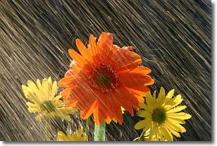
Precipitation can refer to many different forms of water that
may fall from clouds. Precipitation occurs after a cloud has become saturated to
the point where its water particles are more dense than the air below the cloud.
In most cases, precipitation will reach the ground, but it is not uncommon for
precipitation to evaporate before it reaches the earth's surface.
When precipitation evaporates before it contacts the ground it is called Virga.
Graupel, hail, sleet, rain, drizzle, and snow are forms of precipitation, but fog
and mist are not considered precipitation because the water vapor which
constitutes them isn't dense enough to fall to the ground.
Next Topic: Rain
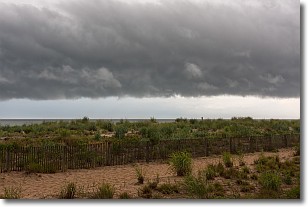
Weather Topic: What are Shelf Clouds?
Home - Education - Cloud Types - Shelf Clouds
 Next Topic: Sleet
A shelf cloud is similar to a wall cloud, but forms at the front
of a storm cloud, instead of at the rear, where wall clouds form.
A shelf cloud is caused by a series of events set into motion by the advancing
storm; first, cool air settles along the ground where precipitation has just fallen.
As the cool air is brought in, the warmer air is displaced, and rises above it,
because it is less dense. When the warmer air reaches the bottom of the storm cloud,
it begins to cool again, and the resulting condensation is a visible shelf cloud.
Next Topic: Sleet
Current conditions powered by WeatherAPI.com


