Weather Alert in Texas
Flood Warning issued July 4 at 2:15PM CDT until July 5 at 8:47AM CDT by NWS Austin/San Antonio TX
AREAS AFFECTED: Kendall, TX
DESCRIPTION: ...The Flood Warning is extended for the following rivers in Texas... Guadalupe River At Comfort affecting Kendall County. Guadalupe River at Hunt affecting Kerr County. Guadalupe River Near Spring Branch affecting Comal County. ...The Flood Warning continues for the following rivers in Texas... Guadalupe River At Kerrville affecting Kerr County. * WHAT...Moderate flooding is occurring and moderate flooding is forecast. * WHERE...Guadalupe River at Comfort. * WHEN...Until tomorrow morning. * IMPACTS...At 28.0 feet, Major flooding reaches the lowest residences above Center Point to near Comfort. Numerous secondary and primary roads are flooded making low bridges and crossings extremely dangerous. Water approaches a mobile home park in Center Point. As the Guadalupe River backs up Cypress Creek in the west part of Comfort, additional flow in Cypress creek floods homes.
INSTRUCTION: Caution is urged when walking near riverbanks. To escape rising water, take the shortest path to higher ground. Turn around, don't drown when encountering flooded roads. Most flood deaths occur in vehicles. Even 6 inches of fast-moving flood water can knock you off your feet and a depth of 2 feet will float your car. Never try to walk, swim, or drive through such swift water. If you come upon flood waters, stop, turn around and go another way. Additional information is available at www.weather.gov. The next issuance will be late tonight by 500 AM CDT.
Want more detail? Get the Complete 7 Day and Night Detailed Forecast!
Current U.S. National Radar--Current
The Current National Weather Radar is shown below with a UTC Time (subtract 5 hours from UTC to get Eastern Time).

National Weather Forecast--Current
The Current National Weather Forecast and National Weather Map are shown below.

National Weather Forecast for Tomorrow
Tomorrow National Weather Forecast and Tomorrow National Weather Map are show below.

North America Water Vapor (Moisture)
This map shows recent moisture content over North America. Bright and colored areas show high moisture (ie, clouds); brown indicates very little moisture present; black indicates no moisture.

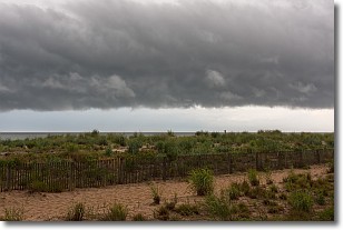
Weather Topic: What are Shelf Clouds?
Home - Education - Cloud Types - Shelf Clouds
 Next Topic: Sleet
A shelf cloud is similar to a wall cloud, but forms at the front
of a storm cloud, instead of at the rear, where wall clouds form.
A shelf cloud is caused by a series of events set into motion by the advancing
storm; first, cool air settles along the ground where precipitation has just fallen.
As the cool air is brought in, the warmer air is displaced, and rises above it,
because it is less dense. When the warmer air reaches the bottom of the storm cloud,
it begins to cool again, and the resulting condensation is a visible shelf cloud.
Next Topic: Sleet
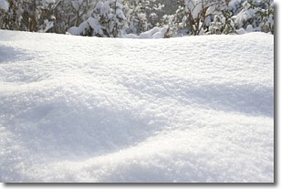
Weather Topic: What is Snow?
Home - Education - Precipitation - Snow
 Next Topic: Stratocumulus Clouds
Snow is precipitation taking the form of ice crystals. Each ice crystal, or snowflake,
has unique characteristics, but all of them grow in a hexagonal structure.
Snowfall can last for sustained periods of time and result in significant buildup
of snow on the ground.
On the earth's surface, snow starts out light and powdery, but as it begins to melt
it tends to become more granular, producing small bits of ice which have the consistency of
sand. After several cycles of melting and freezing, snow can become very dense
and ice-like, commonly known as snow pack.
Next Topic: Stratocumulus Clouds
Current conditions powered by WeatherAPI.com


