Weather Alert in South Dakota
Red Flag Warning issued February 16 at 11:41AM MST until February 17 at 6:00PM MST by NWS Rapid City SD
AREAS AFFECTED: Central Black Hills; Southern Black Hills; Fall River County Area; Eastern Foot Hills; Custer County Plains; Pine Ridge Area; West Central Plains; Haakon County Area; Badlands Area; Bennett County Area; Mellette and Todd Counties; Tripp County; Southern Campbell; Weston County Plains
DESCRIPTION: ...CRITICAL FIRE WEATHER CONDITIONS POSSIBLE TUESDAY... .Very dry air will spread across the region Tuesday, with RH's expected into the mid teens. In addition, strong gusty westerly winds will develop with some areas seeing gusts over 50 mph, especially portions of northeast WY and far southwest SD. The combination of receptive fuels, strong gusty winds, and very low RH would support critical fire weather conditions. The National Weather Service in Rapid City has issued a Red Flag Warning for gusty winds and low relative humidity, which is in effect from 11 AM MST /noon CST/ to 6 PM MST /7 PM CST/ Tuesday. The Fire Weather Watch is no longer in effect. * AFFECTED AREA...Fire Weather Zones 315 Southern Campbell, 317 Weston County Plains, 320 Central Black Hills, 321 Southern Black Hills, 322 Fall River County Area, 324 Eastern Foot Hills, 325 Custer County Plains, 326 Pine Ridge Area, 329 West Central Plains, 331 Haakon County Area, 332 Badlands Area, 333 Bennett County Area, 334 Mellette and Todd Counties and 335 Tripp County. * WINDS...West 25 to 35 mph with gusts up to 55 mph. * RELATIVE HUMIDITY...As low as 15 percent. * IMPACTS...The combination of gusty winds and low relative humidity would produce critical fire weather conditions.
INSTRUCTION: A Red Flag Warning means that critical fire weather conditions are either occurring now, or will shortly. A combination of strong winds, low relative humidity, and warm temperatures can contribute to extreme fire behavior.
Want more detail? Get the Complete 7 Day and Night Detailed Forecast!
Current U.S. National Radar--Current
The Current National Weather Radar is shown below with a UTC Time (subtract 5 hours from UTC to get Eastern Time).

National Weather Forecast--Current
The Current National Weather Forecast and National Weather Map are shown below.

National Weather Forecast for Tomorrow
Tomorrow National Weather Forecast and Tomorrow National Weather Map are show below.

North America Water Vapor (Moisture)
This map shows recent moisture content over North America. Bright and colored areas show high moisture (ie, clouds); brown indicates very little moisture present; black indicates no moisture.

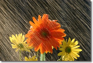
Weather Topic: What is Rain?
Home - Education - Precipitation - Rain
 Next Topic: Shelf Clouds
Precipitation in the form of water droplets is called rain.
Rain generally has a tendency to fall with less intensity over a greater period
of time, and when rainfall is more severe it is usually less sustained.
Rain is the most common form of precipitation and happens with greater frequency
depending on the season and regional influences. Cities have been shown to have
an observable effect on rainfall, due to an effect called the urban heat island.
Compared to upwind, monthly rainfall between twenty and forty miles downwind of
cities is 30% greater.
Next Topic: Shelf Clouds
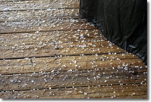
Weather Topic: What is Sleet?
Home - Education - Precipitation - Sleet
 Next Topic: Snow
Sleet is a form of precipitation in which small ice pellets are the primary
components. These ice pellets are smaller and more translucent than hailstones,
and harder than graupel. Sleet is caused by specific atmospheric conditions and
therefore typically doesn't last for extended periods of time.
The condition which leads to sleet formation requires a warmer body of air to be
wedged in between two sub-freezing bodies of air. When snow falls through a warmer
layer of air it melts, and as it falls through the next sub-freezing body of air
it freezes again, forming ice pellets known as sleet. In some cases, water
droplets don't have time to freeze before reaching the surface and the result is
freezing rain.
Next Topic: Snow
Current conditions powered by WeatherAPI.com


