Weather Alert in Wyoming
High Wind Warning issued February 17 at 12:50AM MST until February 17 at 8:00PM MST by NWS Cheyenne WY
AREAS AFFECTED: Shirley Basin; Southwest Carbon County; Upper North Platte River Basin
DESCRIPTION: * WHAT...Southwest winds 30 to 45 mph with gusts around 65 mph. * WHERE...North Snowy Range Foothills including Arlington and Elk Mountain along Interstate 80, Southwest Carbon County, and Upper North Platte River Basin. * WHEN...Until 8 PM MST this evening. * IMPACTS...Mainly to transportation. Strong cross winds will be hazardous to light weight or high profile vehicles, including campers and tractor trailers. * ADDITIONAL DETAILS...Some blowing and drifting snow is possible Tuesday. Blowing snow may result in visibilities below one mile at times.
INSTRUCTION: A High Wind Warning means a hazardous high wind event is expected or occurring. Sustained wind speeds of at least 40 MPH or gusts of 58 MPH or stronger can lead to property damage.
Want more detail? Get the Complete 7 Day and Night Detailed Forecast!
Current U.S. National Radar--Current
The Current National Weather Radar is shown below with a UTC Time (subtract 5 hours from UTC to get Eastern Time).

National Weather Forecast--Current
The Current National Weather Forecast and National Weather Map are shown below.

National Weather Forecast for Tomorrow
Tomorrow National Weather Forecast and Tomorrow National Weather Map are show below.

North America Water Vapor (Moisture)
This map shows recent moisture content over North America. Bright and colored areas show high moisture (ie, clouds); brown indicates very little moisture present; black indicates no moisture.

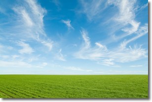
Weather Topic: What are Cirrus Clouds?
Home - Education - Cloud Types - Cirrus Clouds
 Next Topic: Condensation
Cirrus clouds are high-level clouds that occur above 20,000 feet
and are composed mainly of ice crystals.
They are thin and wispy in appearance.
What do they indicate?
They are often the first sign of an approaching storm.
Next Topic: Condensation
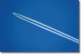
Weather Topic: What are Contrails?
Home - Education - Cloud Types - Contrails
 Next Topic: Cumulonimbus Clouds
A contrail is an artificial cloud, created by the passing of an
aircraft.
Contrails form because water vapor in the exhaust of aircraft engines is suspended
in the air under certain temperatures and humidity conditions. These contrails
are called exhaust contrails.
Another type of contrail can form due to a temporary reduction in air pressure
moving over the plane's surface, causing condensation.
These are called aerodynamic contrails.
When you can see your breath on a cold day, it is also because of condensation.
The reason contrails last longer than the condensation from your breath is
because the water in contrails freezes into ice particles.
Next Topic: Cumulonimbus Clouds
Current conditions powered by WeatherAPI.com


