Weather Alert in Alaska
Hydrologic Outlook issued August 30 at 11:56AM AKDT by NWS Fairbanks AK
AREAS AFFECTED: South Slopes Of The Central Brooks Range; South Slopes of the Western Brooks Range; Noatak Valley; Lower Kobuk Valley; Upper Kobuk Valleys; Lower Koyukuk Valley; Upper Koyukuk Valley
DESCRIPTION: ESFAFG The headwater tributaries of the Koyukuk, Kobuk, and Noatak Rivers have received substantial rainfall this week leading to record crests at Slate Creek near Coldfoot (30 years of record) and Dahl Creek near Kobuk (39 years of record). The crests from the early week rainfall are making their way down the main stems of the Kobuk, Koyukuk, and Noatak Rivers. Rain is expected to return Saturday afternoon with 1 to 2 inches of additional rainfall expected through Tuesday. River levels are now expected to remain high through the middle of next week.
INSTRUCTION: N/A
Want more detail? Get the Complete 7 Day and Night Detailed Forecast!
Current U.S. National Radar--Current
The Current National Weather Radar is shown below with a UTC Time (subtract 5 hours from UTC to get Eastern Time).

National Weather Forecast--Current
The Current National Weather Forecast and National Weather Map are shown below.

National Weather Forecast for Tomorrow
Tomorrow National Weather Forecast and Tomorrow National Weather Map are show below.

North America Water Vapor (Moisture)
This map shows recent moisture content over North America. Bright and colored areas show high moisture (ie, clouds); brown indicates very little moisture present; black indicates no moisture.

Weather Topic: What is Precipitation?
Home - Education - Precipitation - Precipitation
 Next Topic: Rain
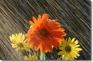
Precipitation can refer to many different forms of water that
may fall from clouds. Precipitation occurs after a cloud has become saturated to
the point where its water particles are more dense than the air below the cloud.
In most cases, precipitation will reach the ground, but it is not uncommon for
precipitation to evaporate before it reaches the earth's surface.
When precipitation evaporates before it contacts the ground it is called Virga.
Graupel, hail, sleet, rain, drizzle, and snow are forms of precipitation, but fog
and mist are not considered precipitation because the water vapor which
constitutes them isn't dense enough to fall to the ground.
Next Topic: Rain
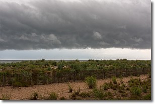
Weather Topic: What are Shelf Clouds?
Home - Education - Cloud Types - Shelf Clouds
 Next Topic: Sleet
A shelf cloud is similar to a wall cloud, but forms at the front
of a storm cloud, instead of at the rear, where wall clouds form.
A shelf cloud is caused by a series of events set into motion by the advancing
storm; first, cool air settles along the ground where precipitation has just fallen.
As the cool air is brought in, the warmer air is displaced, and rises above it,
because it is less dense. When the warmer air reaches the bottom of the storm cloud,
it begins to cool again, and the resulting condensation is a visible shelf cloud.
Next Topic: Sleet
Current conditions powered by WeatherAPI.com


