Weather Alert in Texas
Special Weather Statement issued September 5 at 8:29PM CDT by NWS Fort Worth TX
AREAS AFFECTED: Fannin; Lamar; Collin; Hunt; Delta
DESCRIPTION: At 828 PM CDT, Doppler radar was tracking strong thunderstorms along a line extending from near Bonham to Blue Ridge. Movement was east at 40 mph. HAZARD...Wind gusts of 50 to 55 mph and nickel size hail. SOURCE...Radar indicated. IMPACT...Gusty winds could knock down tree limbs and blow around unsecured objects. Minor damage to outdoor objects is possible. Strong thunderstorms will be near... Honey Grove, Crockett Lake, and Coffee Mill Lake around 835 PM CDT. Roxton and Big Creek Lake around 850 PM CDT. Paris, Cooper, Sumner, and Lake Gibbons around 855 PM CDT. Lake Crook and Pat Mayse Lake around 900 PM CDT. Reno and Camp Maxey around 905 PM CDT. Powderly around 910 PM CDT. Blossom, Arthur City, and Pattonville around 915 PM CDT. Other locations impacted by these storms include Charleston, Lake Creek, Pacio, Nobility, Direct, Midcity, Forest Hill, Ely, Taylor Town, and Sun Valley.
INSTRUCTION: Frequent cloud to ground lightning is occurring with these storms. Lightning can strike 10 miles away from a thunderstorm. Seek a safe shelter inside a building or vehicle.
Want more detail? Get the Complete 7 Day and Night Detailed Forecast!
Current U.S. National Radar--Current
The Current National Weather Radar is shown below with a UTC Time (subtract 5 hours from UTC to get Eastern Time).

National Weather Forecast--Current
The Current National Weather Forecast and National Weather Map are shown below.

National Weather Forecast for Tomorrow
Tomorrow National Weather Forecast and Tomorrow National Weather Map are show below.

North America Water Vapor (Moisture)
This map shows recent moisture content over North America. Bright and colored areas show high moisture (ie, clouds); brown indicates very little moisture present; black indicates no moisture.

Weather Topic: What is Drizzle?
Home - Education - Precipitation - Drizzle
 Next Topic: Evaporation
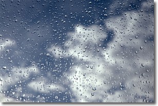
Drizzle is precipitation in the form of water droplets which are
smaller than raindrops.
Drizzle is characterized by fine, gently falling droplets and typically does not
impact human habitation in a negative way. The exception to this is freezing drizzle,
a condition where drizzle freezes immediately upon reaching earth's surface.
Freezing drizzle is still less dangerous than freezing rain, but can
potentially result in hazardous road conditions.
Next Topic: Evaporation
Weather Topic: What is Fog?
Home - Education - Cloud Types - Fog
 Next Topic: Fractus Clouds
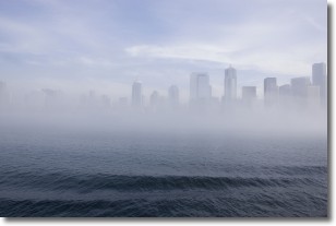
Fog is technically a type of stratus cloud, which lies along the
ground and obscures visibility.
It is usually created when humidity in the air condenses into tiny water droplets.
Because of this, some places are more prone to foggy weather, such as regions
close to a body of water.
Fog is similar to mist; both are the appearance of water droplets suspended in
the air, but fog is the term applied to the condition when visibility is less than 1 km.
Next Topic: Fractus Clouds
Current conditions powered by WeatherAPI.com


