Weather Alert in Oregon
Winter Weather Advisory issued February 16 at 4:21AM PST until February 19 at 10:00AM PST by NWS Medford OR
AREAS AFFECTED: Eastern Douglas County Foothills; South Central Oregon Cascades; Siskiyou Mountains and Southern Oregon Cascades
DESCRIPTION: * WHAT...Snow expected. Total snow accumulations 10 to 15 inches, with up to 2 ft expected above 5000 ft. Winds gusting as high as 35 mph over high and exposed terrain. * WHERE...The southern Oregon Cascades and Siskiyou Mountains, and Eastern Douglas County Foothills. Including the locations of...Toketee Falls, Steamboat, Crescent Lake, Diamond Lake, Union Creek, Howard Prairie. This also includes the following passes or notable locations... Siskiyou Pass on I-5 at 4310 ft. Lake of the Woods on 140 at 5070 ft. Diamond Lake Junction on state highways 230 & 138 at 4478 ft. Mt. Ashland ski road and lodge at 6500 ft. Caves National Monument near highway 46 at 4000 ft. Willamette Pass on state highway 58 at 5090 ft. * WHEN...From 10 PM this evening to 10 AM PST Thursday. * IMPACTS...Travel may be very difficult to impossible. The hazardous conditions could impact the Tuesday morning and evening commutes. * ADDITIONAL DETAILS...The heaviest snow is expected tonight into early Tuesday morning. Visit weather.gov/mfr/winter for snow probabilities.
INSTRUCTION: Slow down and use caution while traveling. Call 511 or visit tripcheck.com for road information.
Want more detail? Get the Complete 7 Day and Night Detailed Forecast!
Current U.S. National Radar--Current
The Current National Weather Radar is shown below with a UTC Time (subtract 5 hours from UTC to get Eastern Time).

National Weather Forecast--Current
The Current National Weather Forecast and National Weather Map are shown below.

National Weather Forecast for Tomorrow
Tomorrow National Weather Forecast and Tomorrow National Weather Map are show below.

North America Water Vapor (Moisture)
This map shows recent moisture content over North America. Bright and colored areas show high moisture (ie, clouds); brown indicates very little moisture present; black indicates no moisture.

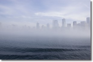
Weather Topic: What is Fog?
Home - Education - Cloud Types - Fog
 Next Topic: Fractus Clouds
Fog is technically a type of stratus cloud, which lies along the
ground and obscures visibility.
It is usually created when humidity in the air condenses into tiny water droplets.
Because of this, some places are more prone to foggy weather, such as regions
close to a body of water.
Fog is similar to mist; both are the appearance of water droplets suspended in
the air, but fog is the term applied to the condition when visibility is less than 1 km.
Next Topic: Fractus Clouds
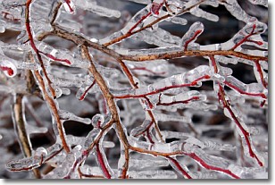
Weather Topic: What is Freezing Rain?
Home - Education - Precipitation - Freezing Rain
 Next Topic: Graupel
Freezing rain is a condition where precipitation which has fallen in the form of
water droplets reaches temperatures which are below freezing and freezes upon
coming into contact
with surface objects. The result of this precipitation is a glaze of ice which
can be damaging to plants and man-made structures. A severe onset of freezing
rain which results in a very thick glaze of ice is known as an ice storm.
Next Topic: Graupel
Current conditions powered by WeatherAPI.com


