Weather Alert in Arizona
Special Weather Statement issued September 3 at 9:25PM MST by NWS Phoenix AZ
AREAS AFFECTED: Cave Creek/New River; Deer Valley; Central Phoenix; North Phoenix/Glendale; New River Mesa; Scottsdale/Paradise Valley; East Valley
DESCRIPTION: At 925 PM MST, Doppler radar was tracking a cluster of strong thunderstorms over Desert Ridge Marketplace, or near Scottsdale. These storms were nearly stationary. HAZARD...Wind gusts up to 50 mph. SOURCE...Radar indicated. IMPACT...Gusty winds could knock down tree limbs and blow around unsecured objects. Locations impacted include... Phoenix, Glendale, Scottsdale, Tempe, Paradise Valley, New River, Cave Creek, Carefree, Papago Park, Piestewa Peak Park, Deer Valley Airport, North Mountain Park, Arizona State Fairgrounds, Downtown Scottsdale, Downtown Glendale, Metro Center, Desert Mountain, Scottsdale Airport, Camelback Mountain, and Sky Harbor Airport. This includes the following highways... AZ Interstate 10 between mile markers 145 and 149. AZ Interstate 17 between mile markers 202 and 219. AZ Route 51 between mile markers 1 and 15.
INSTRUCTION: If outdoors, consider seeking shelter inside a building.
Want more detail? Get the Complete 7 Day and Night Detailed Forecast!
Current U.S. National Radar--Current
The Current National Weather Radar is shown below with a UTC Time (subtract 5 hours from UTC to get Eastern Time).

National Weather Forecast--Current
The Current National Weather Forecast and National Weather Map are shown below.

National Weather Forecast for Tomorrow
Tomorrow National Weather Forecast and Tomorrow National Weather Map are show below.

North America Water Vapor (Moisture)
This map shows recent moisture content over North America. Bright and colored areas show high moisture (ie, clouds); brown indicates very little moisture present; black indicates no moisture.

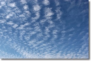
Weather Topic: What are Altocumulus Clouds?
Home - Education - Cloud Types - Altocumulus Clouds
 Next Topic: Altostratus Clouds
Similar to cirrocumulus clouds, altocumulus clouds are
characterized by cloud patches. They are distinguished by larger cloudlets
than cirrocumulus clouds but are still smaller than stratocumulus clouds.
Altocumulus clouds most commonly form in middle altitudes (between 2 and 5 km)
and may resemble, at times, the shape of a flying saucer.
These uncommon formations, called altocumulus lenticularis, are created by uplift
in the atmosphere and are most often seen in close proximity to mountains.
Next Topic: Altostratus Clouds
Weather Topic: What are Cirrocumulus Clouds?
Home - Education - Cloud Types - Cirrocumulus Clouds
 Next Topic: Cirrostratus Clouds
Cirrocumulus clouds form at high altitudes (usually around 5 km)
and have distinguishing characteristics displayed in a fine layer of
small cloud patches. These small cloud patches are sometimes referred to as
"cloudlets" in relation to the whole cloud formation.
Cirrocumulus clouds are formed from ice crystals and water droplets. Often, the
water droplets in the cloud freeze into ice crystals and the cloud becomes a
cirrostratus cloud. Because of this common occurrence, cirrocumulus cloud
formations generally pass rapidly.
Next Topic: Cirrostratus Clouds
Current conditions powered by WeatherAPI.com


