Weather Alert in Minnesota
Winter Weather Advisory issued February 28 at 4:12AM CST until February 28 at 5:00PM CST by NWS Twin Cities/Chanhassen MN
AREAS AFFECTED: Stevens; Lac Qui Parle; Swift; Chippewa; Kandiyohi; Meeker; Yellow Medicine; Renville; McLeod; Sibley; Redwood; Brown; Nicollet
DESCRIPTION: ...BAND OF HEAVY SNOW TODAY ALONG THE MINNESOTA RIVER VALLEY... .A quick hitting band of snow is expected this morning through the afternoon. Amounts will generally be on the order of 2 to 4 inches, but a narrow band of higher amounts (up to 6 inches) will likely set up somewhere within the advisory area. Snowfall rates may approach one inch per hour, which will lead to visibility reductions and hazardous travel. Snow will gradually end from west to east by this evening. * WHAT...Snow. Additional snow accumulations between 2 and 4 inches. * WHERE...Kandiyohi, McLeod, Meeker, Renville, Sibley, Brown, Nicollet, Redwood, Chippewa, Lac Qui Parle, Stevens, Swift, and Yellow Medicine Counties. * WHEN...Until 5 PM CST this afternoon. * IMPACTS...Plan on slippery road conditions.
INSTRUCTION: Slow down and use caution while traveling. Call 5 1 1 or visit 511mn.org for road conditions.
Want more detail? Get the Complete 7 Day and Night Detailed Forecast!
Current U.S. National Radar--Current
The Current National Weather Radar is shown below with a UTC Time (subtract 5 hours from UTC to get Eastern Time).

National Weather Forecast--Current
The Current National Weather Forecast and National Weather Map are shown below.

National Weather Forecast for Tomorrow
Tomorrow National Weather Forecast and Tomorrow National Weather Map are show below.

North America Water Vapor (Moisture)
This map shows recent moisture content over North America. Bright and colored areas show high moisture (ie, clouds); brown indicates very little moisture present; black indicates no moisture.

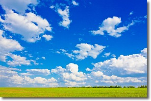
Weather Topic: What are Cumulus Clouds?
Home - Education - Cloud Types - Cumulus Clouds
 Next Topic: Drizzle
Cumulus clouds are fluffy and textured with rounded tops, and
may have flat bottoms. The border of a cumulus cloud
is clearly defined, and can have the appearance of cotton or cauliflower.
Cumulus clouds form at low altitudes (rarely above 2 km) but can grow very tall,
becoming cumulus congestus and possibly the even taller cumulonimbus clouds.
When cumulus clouds become taller, they have a greater chance of producing precipitation.
Next Topic: Drizzle
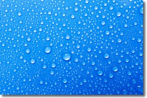
Weather Topic: What is Evaporation?
Home - Education - Precipitation - Evaporation
 Next Topic: Fog
Evaporation is the process which returns water from the earth
back to the atmosphere, and is another crucial process in the water cycle.
Evaporation is the transformation of liquid into gas, and it happens because
molecules are excited by the application of energy and turn into vapor.
In order for water to evaporate it has to be on the surface of a body of water.
Next Topic: Fog
Current conditions powered by WeatherAPI.com


