Weather Alert in California
Flood Advisory issued February 16 at 9:49AM PST until February 16 at 4:00PM PST by NWS Sacramento CA
AREAS AFFECTED: Amador, CA; Calaveras, CA; El Dorado, CA; Placer, CA; Sacramento, CA; San Joaquin, CA; Stanislaus, CA; Yolo, CA
DESCRIPTION: * WHAT...Urban and small stream flooding caused by excessive rainfall. * WHERE...Portions of Placer, Amador, Calaveras, El Dorado, Sacramento, San Joaquin, Stanislaus and Yolo Counties. * WHEN...Until 400 PM PST Monday. * IMPACTS...Minor flooding in low-lying and poor drainage areas. Water over roadways. Ponding of water in urban or other areas is occurring or is imminent. * ADDITIONAL DETAILS... - At 946 AM PST, Local law enforcement reported flooding in the advisory area. Between 1 and 2 inches of rain have fallen over the past 12 hours. - Some locations that will experience flooding include... Sacramento, Stockton, Elk Grove, Roseville, Citrus Heights, Folsom, Rocklin, Galt, Fair Oaks, Carmichael, El Dorado Hills, Cameron Park, Rancho Cordova, Lodi, West Sacramento, Lathrop, Ione, Loomis, Rancho Murieta and Rancho Seco Park. - US Highway 50 - http://www.weather.gov/safety/flood
INSTRUCTION: Turn around, don't drown when encountering flooded roads. Most flood deaths occur in vehicles. Be aware of your surroundings and do not drive on flooded roads.
Want more detail? Get the Complete 7 Day and Night Detailed Forecast!
Current U.S. National Radar--Current
The Current National Weather Radar is shown below with a UTC Time (subtract 5 hours from UTC to get Eastern Time).

National Weather Forecast--Current
The Current National Weather Forecast and National Weather Map are shown below.

National Weather Forecast for Tomorrow
Tomorrow National Weather Forecast and Tomorrow National Weather Map are show below.

North America Water Vapor (Moisture)
This map shows recent moisture content over North America. Bright and colored areas show high moisture (ie, clouds); brown indicates very little moisture present; black indicates no moisture.

Weather Topic: What are Hole Punch Clouds?
Home - Education - Cloud Types - Hole Punch Clouds
 Next Topic: Mammatus Clouds
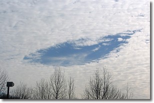
A hole punch cloud is an unusual occurrence when a disk-shaped
hole appears in a cirrostratus, cirrocumulus, or altocumulus cloud.
When part of the cloud forms ice crystals, water droplets in the surrounding area
of the cloud evaporate. The effect of this process produces a large elliptical
gap in the cloud. The hole punch cloud formation is rare, but it is not specific
to any geographic area.
Other names which have been used to describe this phenomena include fallstreak hole,
skypunch, and cloud hole.
Next Topic: Mammatus Clouds
Weather Topic: What are Nimbostratus Clouds?
Home - Education - Cloud Types - Nimbostratus Clouds
 Next Topic: Precipitation
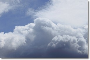
A nimbostratus cloud is similar to a stratus cloud in its formless,
smooth appearance. However, a nimbostratus cloud is darker than a stratus cloud,
because it is thicker.
Unlike a stratus cloud, a nimbostratus cloud typically brings with it the threat
of moderate to heavy precipitation. In some cases, the precipitation may evaporate
before reaching the ground, a phenomenon known as virga.
Next Topic: Precipitation
Current conditions powered by WeatherAPI.com


