Weather Alert in Wisconsin
Winter Storm Warning issued February 16 at 1:23PM CST until February 19 at 12:00PM CST by NWS Duluth MN
AREAS AFFECTED: Douglas; Bayfield
DESCRIPTION: * WHAT...Heavy snow with light ice accumulations expected. Total snow accumulations of 5 to 8 inches for northern Douglas and Bayfield Counties, elsewhere between 2 and 4 inches of snow. ice accumulations around one tenth of an inch. Winds gusting as high as 40 mph. * WHERE...Bayfield and Douglas Counties. This includes the Tribal Lands of the Red Cliff Band. Other locations including the Apostle Islands National Lakeshore. * WHEN...From 6 PM Tuesday to noon CST Thursday. * IMPACTS...Travel could be very difficult. The hazardous conditions could impact the Wednesday morning and evening commutes. * ADDITIONAL DETAILS...Light ice accumulations on surfaces is most likely Tuesday evening and overnight. The heaviest snowfall in the far northern parts of the Counties is expected late Tuesday night through Wednesday mid day.
INSTRUCTION: If you must travel, keep an extra flashlight, food, and water in your vehicle in case of an emergency. Call 511 or visit www.511wi.gov for Wisconsin road information.
Want more detail? Get the Complete 7 Day and Night Detailed Forecast!
Current U.S. National Radar--Current
The Current National Weather Radar is shown below with a UTC Time (subtract 5 hours from UTC to get Eastern Time).

National Weather Forecast--Current
The Current National Weather Forecast and National Weather Map are shown below.

National Weather Forecast for Tomorrow
Tomorrow National Weather Forecast and Tomorrow National Weather Map are show below.

North America Water Vapor (Moisture)
This map shows recent moisture content over North America. Bright and colored areas show high moisture (ie, clouds); brown indicates very little moisture present; black indicates no moisture.

Weather Topic: What is Condensation?
Home - Education - Precipitation - Condensation
 Next Topic: Contrails
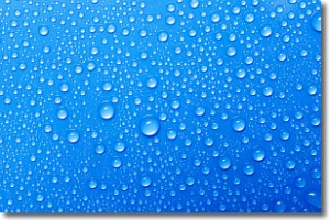
Condensation is the process which creates clouds, and therefore
it is a crucial process in the water cycle.
Condensation is the change of matter from a state of gas into a state of liquid,
and it happens because water molecules release heat into the atmosphere and
become organized into a more closely packed structure, what we might see as
water droplets.
Water is always present in the air around us as a vapor, but it's too small for
us to see. When water undergoes the process of condensation it becomes organized
into visible water droplets. You've probably seen condensation happen before on the
surface of a cold drink!
Next Topic: Contrails
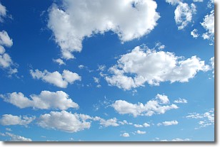
Weather Topic: What are Cumulonimbus Clouds?
Home - Education - Cloud Types - Cumulonimbus Clouds
 Next Topic: Cumulus Clouds
The final form taken by a growing cumulus cloud is the
cumulonimbus cloud, which is very tall and dense.
The tower of a cumulonimbus cloud can soar 23 km into the atmosphere, although
most commonly they stop growing at an altitude of 6 km.
Even small cumulonimbus clouds appear very large in comparison to other cloud types.
They can signal the approach of stormy weather, such as thunderstorms or blizzards.
Next Topic: Cumulus Clouds
Current conditions powered by WeatherAPI.com


