Weather Alert in Minnesota
Winter Storm Watch issued February 16 at 1:23PM CST until February 19 at 12:00PM CST by NWS Duluth MN
AREAS AFFECTED: Koochiching; North St. Louis; North Itasca; North Cass; South Itasca; Northern Aitkin
DESCRIPTION: * WHAT...Heavy mixed precipitation possible. Total snow accumulations between 4 and 7 inches and ice accumulations up to one tenth inch possible. Winds could gust as high as 40 mph. * WHERE...Northern Aitkin, Koochiching, North Cass, Itasca, and North St. Louis Counties. This includes the Tribal Lands of the Mille Lacs Band, Big Sandy Lake area and the Bois Forte Band, Deer Creek and, Nett Lake areas. Other locations including Voyageurs National Park. This also includes the Boundary Waters western area. * WHEN...From Tuesday evening through Thursday morning. * IMPACTS...Travel could be very difficult. The hazardous conditions could impact the Wednesday morning and evening commutes. * ADDITIONAL DETAILS...The best potential for a wintry mix will be along and south of the Iron Range Tuesday evening into Wednesday morning.
INSTRUCTION: Monitor the latest forecasts for updates on this situation. Persons should consider delaying all travel. If travel is absolutely necessary, drive with extreme caution. Consider taking a winter storm kit along with you, including such items as tire chains, booster cables, flashlight, shovel, blankets and extra clothing. Also take water, a first aid kit, and anything else that would help you survive in case you become stranded.
Want more detail? Get the Complete 7 Day and Night Detailed Forecast!
Current U.S. National Radar--Current
The Current National Weather Radar is shown below with a UTC Time (subtract 5 hours from UTC to get Eastern Time).

National Weather Forecast--Current
The Current National Weather Forecast and National Weather Map are shown below.

National Weather Forecast for Tomorrow
Tomorrow National Weather Forecast and Tomorrow National Weather Map are show below.

North America Water Vapor (Moisture)
This map shows recent moisture content over North America. Bright and colored areas show high moisture (ie, clouds); brown indicates very little moisture present; black indicates no moisture.

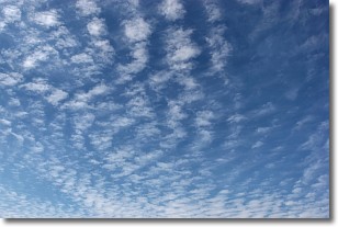
Weather Topic: What are Altocumulus Clouds?
Home - Education - Cloud Types - Altocumulus Clouds
 Next Topic: Altostratus Clouds
Similar to cirrocumulus clouds, altocumulus clouds are
characterized by cloud patches. They are distinguished by larger cloudlets
than cirrocumulus clouds but are still smaller than stratocumulus clouds.
Altocumulus clouds most commonly form in middle altitudes (between 2 and 5 km)
and may resemble, at times, the shape of a flying saucer.
These uncommon formations, called altocumulus lenticularis, are created by uplift
in the atmosphere and are most often seen in close proximity to mountains.
Next Topic: Altostratus Clouds
Weather Topic: What are Cirrocumulus Clouds?
Home - Education - Cloud Types - Cirrocumulus Clouds
 Next Topic: Cirrostratus Clouds
Cirrocumulus clouds form at high altitudes (usually around 5 km)
and have distinguishing characteristics displayed in a fine layer of
small cloud patches. These small cloud patches are sometimes referred to as
"cloudlets" in relation to the whole cloud formation.
Cirrocumulus clouds are formed from ice crystals and water droplets. Often, the
water droplets in the cloud freeze into ice crystals and the cloud becomes a
cirrostratus cloud. Because of this common occurrence, cirrocumulus cloud
formations generally pass rapidly.
Next Topic: Cirrostratus Clouds
Current conditions powered by WeatherAPI.com


