Weather Alert in Minnesota
Winter Weather Advisory issued April 3 at 2:23AM CDT until April 4 at 10:00PM CDT by NWS Twin Cities/Chanhassen MN
AREAS AFFECTED: Mille Lacs; Kanabec; Stearns; Benton
DESCRIPTION: ...MIXED WINTER EVENT WITH SNOW, SLEET, AND ICE ACCUMULATION FRIDAY INTO SATURDAY... .A mixed precipitation event will unfold across Minnesota into Wisconsin today into tomorrow. Across parts of central Minnesota this will mainly fall as snow with up to 7 inches possible. Farther south a band of freezing rain and sleet from southwest Minnesota to northwest Wisconsin will see ice accumulations up to two tenths of an inch. There will be a sharp cutoff in these ice accumulations, as this will be very sensitive to where the freezing line sets up. So additional shifts in the southward extent maybe needed later in the day. * WHAT...Mixed precipitation expected. Total snow accumulations between 2 and 4 inches, sleet accumulations around one quarter of an inch, and ice accumulations up to one tenth of an inch. * WHERE...Benton, Stearns, Kanabec, and Mille Lacs Counties. * WHEN...From 4 PM this afternoon to 10 PM CDT Saturday. * IMPACTS...Plan on slippery road conditions. The hazardous conditions will impact the Friday evening commute.
INSTRUCTION: Slow down and use caution while traveling. In Minnesota, call 5 1 1 or visit 511mn.org for road conditions. In Wisconsin, call 5 1 1 or visit 511wi.gov for road conditions.
Want more detail? Get the Complete 7 Day and Night Detailed Forecast!
Current U.S. National Radar--Current
The Current National Weather Radar is shown below with a UTC Time (subtract 5 hours from UTC to get Eastern Time).

National Weather Forecast--Current
The Current National Weather Forecast and National Weather Map are shown below.

National Weather Forecast for Tomorrow
Tomorrow National Weather Forecast and Tomorrow National Weather Map are show below.

North America Water Vapor (Moisture)
This map shows recent moisture content over North America. Bright and colored areas show high moisture (ie, clouds); brown indicates very little moisture present; black indicates no moisture.

Weather Topic: What is Condensation?
Home - Education - Precipitation - Condensation
 Next Topic: Contrails
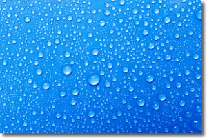
Condensation is the process which creates clouds, and therefore
it is a crucial process in the water cycle.
Condensation is the change of matter from a state of gas into a state of liquid,
and it happens because water molecules release heat into the atmosphere and
become organized into a more closely packed structure, what we might see as
water droplets.
Water is always present in the air around us as a vapor, but it's too small for
us to see. When water undergoes the process of condensation it becomes organized
into visible water droplets. You've probably seen condensation happen before on the
surface of a cold drink!
Next Topic: Contrails
Weather Topic: What are Cumulonimbus Clouds?
Home - Education - Cloud Types - Cumulonimbus Clouds
 Next Topic: Cumulus Clouds
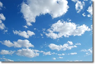
The final form taken by a growing cumulus cloud is the
cumulonimbus cloud, which is very tall and dense.
The tower of a cumulonimbus cloud can soar 23 km into the atmosphere, although
most commonly they stop growing at an altitude of 6 km.
Even small cumulonimbus clouds appear very large in comparison to other cloud types.
They can signal the approach of stormy weather, such as thunderstorms or blizzards.
Next Topic: Cumulus Clouds
Current conditions powered by WeatherAPI.com


