Weather Alert in Nevada
Dust Advisory issued September 2 at 5:58PM PDT until September 2 at 8:00PM PDT by NWS Reno NV
AREAS AFFECTED: Churchill, NV; Lyon, NV; Pershing, NV; Storey, NV; Washoe, NV
DESCRIPTION: The National Weather Service in Reno has issued a * Dust Advisory for... Northwestern Churchill County in west central Nevada... Storey County in western Nevada... Southern Washoe County in western Nevada... Western Pershing County in west central Nevada... North central Lyon County in west central Nevada... * Until 800 PM PDT. * At 554 PM PDT, an area of blowing dust may impact portions of I-80 from Fernley to Imlay. HAZARD...Less than one mile visibility with strong wind gusts in excess of 45 mph. SOURCE...Doppler radar. IMPACT...Hazardous travel. * Sudden reductions to visibility are possible along stretches of Interstate 80 from Fernley to Imlay which includes Lovelock. Locations impacted include... Lovelock, Fernley, Oreana, Imlay, Unionville, Nixon, Trinity Junction, Junction I 80 And Nv 396/857 (exit 112), Seven Troughs Mountain, Rye Patch Reservoir, Junction I 80 And U.S 95 (exit 83), Star Peak, Trinity Peak, Rye Patch Reservoir Campground, Juniper Mountain, Desert Peak, Majuba Mountain, Mill City, Fernley - Tiger Field Airport, and Lovelock Derby Field Airport.
INSTRUCTION: Blowing dust can be hazardous. Delay or reroute travel. Remain aware of the weather.
Want more detail? Get the Complete 7 Day and Night Detailed Forecast!
Current U.S. National Radar--Current
The Current National Weather Radar is shown below with a UTC Time (subtract 5 hours from UTC to get Eastern Time).

National Weather Forecast--Current
The Current National Weather Forecast and National Weather Map are shown below.

National Weather Forecast for Tomorrow
Tomorrow National Weather Forecast and Tomorrow National Weather Map are show below.

North America Water Vapor (Moisture)
This map shows recent moisture content over North America. Bright and colored areas show high moisture (ie, clouds); brown indicates very little moisture present; black indicates no moisture.

Weather Topic: What is Drizzle?
Home - Education - Precipitation - Drizzle
 Next Topic: Evaporation
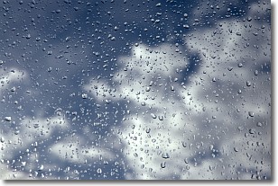
Drizzle is precipitation in the form of water droplets which are
smaller than raindrops.
Drizzle is characterized by fine, gently falling droplets and typically does not
impact human habitation in a negative way. The exception to this is freezing drizzle,
a condition where drizzle freezes immediately upon reaching earth's surface.
Freezing drizzle is still less dangerous than freezing rain, but can
potentially result in hazardous road conditions.
Next Topic: Evaporation
Weather Topic: What is Fog?
Home - Education - Cloud Types - Fog
 Next Topic: Fractus Clouds
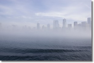
Fog is technically a type of stratus cloud, which lies along the
ground and obscures visibility.
It is usually created when humidity in the air condenses into tiny water droplets.
Because of this, some places are more prone to foggy weather, such as regions
close to a body of water.
Fog is similar to mist; both are the appearance of water droplets suspended in
the air, but fog is the term applied to the condition when visibility is less than 1 km.
Next Topic: Fractus Clouds
Current conditions powered by WeatherAPI.com


