Weather Alert in New Mexico
High Wind Warning issued February 16 at 11:52AM MST until February 17 at 10:00PM MST by NWS Midland/Odessa TX
AREAS AFFECTED: Eddy County Plains; Northern Lea County; Central Lea County; Eastern Culberson County
DESCRIPTION: * WHAT...For the Blowing Dust Advisory, visibility between one-quarter and one mile in blowing dust expected. For the High Wind Warning, southwest winds 30 to 40 mph with gusts up to 65 mph expected. * WHERE...In New Mexico, Central Lea and Northern Lea Counties, and Eddy County Plains. In Texas, Eastern Culberson County. * WHEN...From 5 AM MST /6 AM CST/ to 10 PM MST /11 PM CST/ Tuesday. * IMPACTS...Hazardous driving conditions due to reduced visibility. A sudden gust of wind could drop visibility to near zero instantly. Travel will be difficult, especially for high profile vehicles like campers, vans, and tractor trailers. Blowing dust can reduce visibility suddenly to zero, especially in areas where bare fields exist. Severe turbulence near the mountains will be hazardous for low flying light aircraft.
INSTRUCTION: Slow down, use low-beam headlights, and leave plenty of distance between you and other vehicles. Use caution if flying low near the mountains as severe turbulence is possible. Use caution when driving as blowing dust may reduce visibility.
Want more detail? Get the Complete 7 Day and Night Detailed Forecast!
Current U.S. National Radar--Current
The Current National Weather Radar is shown below with a UTC Time (subtract 5 hours from UTC to get Eastern Time).

National Weather Forecast--Current
The Current National Weather Forecast and National Weather Map are shown below.

National Weather Forecast for Tomorrow
Tomorrow National Weather Forecast and Tomorrow National Weather Map are show below.

North America Water Vapor (Moisture)
This map shows recent moisture content over North America. Bright and colored areas show high moisture (ie, clouds); brown indicates very little moisture present; black indicates no moisture.

Weather Topic: What is Hail?
Home - Education - Precipitation - Hail
 Next Topic: Hole Punch Clouds
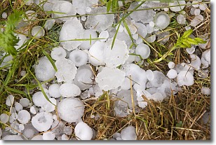
Hail is a form of precipitation which is recognized by large solid balls or
clumps of ice. Hail is created by thunderstorm clouds with strong updrafts of wind.
As the hailstones remain in the updraft, ice is deposited onto them until their
weight becomes heavy enough for them to fall to the earth's surface.
Hail storms can cause significant damage to crops, aircrafts, and man-made structures,
despite the fact that the duration is usually less than ten minutes.
Next Topic: Hole Punch Clouds
Weather Topic: What are Mammatus Clouds?
Home - Education - Cloud Types - Mammatus Clouds
 Next Topic: Nimbostratus Clouds
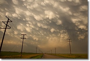
A mammatus cloud is a cloud with a unique feature which resembles
a web of pouches hanging along the base of the cloud.
In the United States, mammatus clouds tend to form in the warmer months, commonly
in the Midwest and eastern regions.
While they usually form at the bottom of a cumulonimbis cloud, they can also form
under altostratus, altocumulus, stratocumulus, and cirrus clouds. Mammatus clouds
warn that severe weather is close.
Next Topic: Nimbostratus Clouds
Current conditions powered by WeatherAPI.com


