Weather Alert in New Mexico
Red Flag Warning issued February 16 at 5:43PM MST until February 17 at 7:00PM MST by NWS Albuquerque NM
AREAS AFFECTED: Northeast Highlands
DESCRIPTION: ...RED FLAG WARNING IN EFFECT FROM 10 AM TO 7 PM TUESDAY FOR THE NORTHEAST HIGHLANDS, NORTHEAST PLAINS, AND EAST CENTRAL PLAINS DUE TO STRONG WINDS AND LOW HUMIDITY... ...FIRE WEATHER WATCH IN EFFECT FROM 10 AM TO 7 PM WEDNESDAY FOR ALL OF EASTERN NEW MEXICO AND THE MIDDLE RIO GRANDE VALLEY DUE TO STRONG WINDS AND LOW HUMIDITY... .Strong to damaging southwest to west winds will impact New Mexico Tuesday with critical fire weather conditions over a large area of eastern NM. Peak wind gusts of 55 to 70 mph with minimum humidity values of 15 to 20% will allow for rapid fire spread among fine fuels. Another day of strong to potentially damaging winds are expected on Wednesday, and humidity values will be much lower than on Tuesday. Minimum humidity values on Wednesday will be between 8 and 18% across central and eastern NM. Any fires that are started on Tuesday may continue to burn through Wednesday. Critical fire weather conditions may also return on Thursday across eastern NM. * AREA AND TIMING...Northeast Highlands (Zone 123) Tuesday and Wednesday. * 20 FOOT WINDS...For Tuesday, southwest to west 30 to 40 mph with peak gusts of 55 to 70 mph. For Wednesday, southwest winds of 25 to 40 mph with peak gusts up to 55 mph. * RELATIVE HUMIDITY...For Tuesday afternoon, minimum values of 15 to 20%. For Wednesday afternoon, minimum values of 12 to 18%. * IMPACTS...Any fires that develop will likely spread rapidly. Outdoor burning is not recommended.
INSTRUCTION: Please advise the appropriate officials or fire crews in the field of this Red Flag Warning. Please advise the appropriate officials or fire crews in the field of this Fire Weather Watch.
Want more detail? Get the Complete 7 Day and Night Detailed Forecast!
Current U.S. National Radar--Current
The Current National Weather Radar is shown below with a UTC Time (subtract 5 hours from UTC to get Eastern Time).

National Weather Forecast--Current
The Current National Weather Forecast and National Weather Map are shown below.

National Weather Forecast for Tomorrow
Tomorrow National Weather Forecast and Tomorrow National Weather Map are show below.

North America Water Vapor (Moisture)
This map shows recent moisture content over North America. Bright and colored areas show high moisture (ie, clouds); brown indicates very little moisture present; black indicates no moisture.

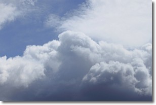
Weather Topic: What are Nimbostratus Clouds?
Home - Education - Cloud Types - Nimbostratus Clouds
 Next Topic: Precipitation
A nimbostratus cloud is similar to a stratus cloud in its formless,
smooth appearance. However, a nimbostratus cloud is darker than a stratus cloud,
because it is thicker.
Unlike a stratus cloud, a nimbostratus cloud typically brings with it the threat
of moderate to heavy precipitation. In some cases, the precipitation may evaporate
before reaching the ground, a phenomenon known as virga.
Next Topic: Precipitation
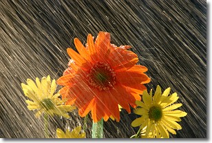
Weather Topic: What is Rain?
Home - Education - Precipitation - Rain
 Next Topic: Shelf Clouds
Precipitation in the form of water droplets is called rain.
Rain generally has a tendency to fall with less intensity over a greater period
of time, and when rainfall is more severe it is usually less sustained.
Rain is the most common form of precipitation and happens with greater frequency
depending on the season and regional influences. Cities have been shown to have
an observable effect on rainfall, due to an effect called the urban heat island.
Compared to upwind, monthly rainfall between twenty and forty miles downwind of
cities is 30% greater.
Next Topic: Shelf Clouds
Current conditions powered by WeatherAPI.com


