Weather Alert in New Mexico
Fire Weather Watch issued February 16 at 5:43PM MST until February 18 at 7:00PM MST by NWS Albuquerque NM
AREAS AFFECTED: Middle Rio Grande Valley; Central Highlands
DESCRIPTION: ...RED FLAG WARNING IN EFFECT FROM 10 AM TO 7 PM TUESDAY FOR THE NORTHEAST HIGHLANDS, NORTHEAST PLAINS, AND EAST CENTRAL PLAINS DUE TO STRONG WINDS AND LOW HUMIDITY... ...FIRE WEATHER WATCH IN EFFECT FROM 10 AM TO 7 PM WEDNESDAY FOR ALL OF EASTERN NEW MEXICO AND THE MIDDLE RIO GRANDE VALLEY DUE TO STRONG WINDS AND LOW HUMIDITY... .Strong to damaging southwest to west winds will impact New Mexico Tuesday with critical fire weather conditions over a large area of eastern NM. Peak wind gusts of 55 to 70 mph with minimum humidity values of 15 to 20% will allow for rapid fire spread among fine fuels. Another day of strong to potentially damaging winds are expected on Wednesday, and humidity values will be much lower than on Tuesday. Minimum humidity values on Wednesday will be between 8 and 18% across central and eastern NM. Any fires that are started on Tuesday may continue to burn through Wednesday. Critical fire weather conditions may also return on Thursday across eastern NM. * AREA AND TIMING...Middle Rio Grande Valley (Zone 106) and Central Highlands (Zone 125) from late Wednesday morning through Wednesday evening. * 20 FOOT WINDS...West to southwest 20 to 35 mph with peak gusts between 45 and 55 mph. * RELATIVE HUMIDITY...Minimum values between 11 and 18%. * IMPACTS...Any fires that develop will likely spread rapidly. Outdoor burning is not recommended.
INSTRUCTION: Please advise the appropriate officials or fire crews in the field of this Fire Weather Watch.
Want more detail? Get the Complete 7 Day and Night Detailed Forecast!
Current U.S. National Radar--Current
The Current National Weather Radar is shown below with a UTC Time (subtract 5 hours from UTC to get Eastern Time).

National Weather Forecast--Current
The Current National Weather Forecast and National Weather Map are shown below.

National Weather Forecast for Tomorrow
Tomorrow National Weather Forecast and Tomorrow National Weather Map are show below.

North America Water Vapor (Moisture)
This map shows recent moisture content over North America. Bright and colored areas show high moisture (ie, clouds); brown indicates very little moisture present; black indicates no moisture.

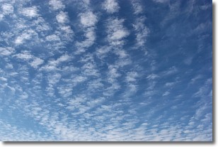
Weather Topic: What are Cirrocumulus Clouds?
Home - Education - Cloud Types - Cirrocumulus Clouds
 Next Topic: Cirrostratus Clouds
Cirrocumulus clouds form at high altitudes (usually around 5 km)
and have distinguishing characteristics displayed in a fine layer of
small cloud patches. These small cloud patches are sometimes referred to as
"cloudlets" in relation to the whole cloud formation.
Cirrocumulus clouds are formed from ice crystals and water droplets. Often, the
water droplets in the cloud freeze into ice crystals and the cloud becomes a
cirrostratus cloud. Because of this common occurrence, cirrocumulus cloud
formations generally pass rapidly.
Next Topic: Cirrostratus Clouds
Weather Topic: What are Cirrus Clouds?
Home - Education - Cloud Types - Cirrus Clouds
 Next Topic: Condensation
Cirrus clouds are high-level clouds that occur above 20,000 feet
and are composed mainly of ice crystals.
They are thin and wispy in appearance.
What do they indicate?
They are often the first sign of an approaching storm.
Next Topic: Condensation
Current conditions powered by WeatherAPI.com


