Weather Alert in California
Winter Storm Warning issued February 15 at 8:11PM PST until February 19 at 9:00AM PST by NWS San Diego CA
AREAS AFFECTED: Riverside County Mountains
DESCRIPTION: * WHAT...Heavy snow expected. For first round Monday, 3-6 inches expected between 6000-7000 ft, 6-12 inches expected above 7000 ft, up to 24 inches above 8000 ft. West winds gusting to 55 mph on the ridges and desert slopes. Occasional light snow during the day Tuesday. Next round of moderate snow Wednesday into Thursday morning with additional snow totals of 4-9 inches 6000-7000 ft, and up to 12 inches above 8000 ft. Wind gusts as high as 70 mph possible on the desert slopes of the mountains late Tuesday and Wednesday. A few additional inches of snow expected Thursday. * WHERE...Riverside County Mountains. * WHEN...From 10 AM Monday to 9 AM PST Thursday. * IMPACTS...Travel could be very difficult to impossible. The hazardous conditions could impact the Monday evening and Tuesday morning commutes. Very strong winds could cause extensive tree damage. * ADDITIONAL DETAILS...For the first round Monday, snow levels will start around 7000 ft and fall to near 5000 ft. Lower snow levels near 4,000 feet possible Wednesday morning and Thursday.
INSTRUCTION: If you must travel, keep an extra flashlight, food, and water in your vehicle in case of an emergency. The latest road conditions for the state you are calling from can be obtained by calling 5 1 1.
Want more detail? Get the Complete 7 Day and Night Detailed Forecast!
Current U.S. National Radar--Current
The Current National Weather Radar is shown below with a UTC Time (subtract 5 hours from UTC to get Eastern Time).

National Weather Forecast--Current
The Current National Weather Forecast and National Weather Map are shown below.

National Weather Forecast for Tomorrow
Tomorrow National Weather Forecast and Tomorrow National Weather Map are show below.

North America Water Vapor (Moisture)
This map shows recent moisture content over North America. Bright and colored areas show high moisture (ie, clouds); brown indicates very little moisture present; black indicates no moisture.

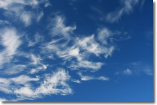
Weather Topic: What are Altostratus Clouds?
Home - Education - Cloud Types - Altostratus Clouds
 Next Topic: Cirrocumulus Clouds
Altostratus clouds form at mid to high-level altitudes
(between 2 and 7 km) and are created by a warm, stable air mass which causes
water vapor
to condense as it rise through the atmosphere. Usually altostratus clouds are
featureless sheets characterized by a uniform color.
In some cases, wind punching through the cloud formation may give it a waved
appearance, called altostratus undulatus. Altostratus clouds
are commonly seen with other cloud formations accompanying them.
Next Topic: Cirrocumulus Clouds
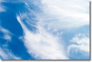
Weather Topic: What are Cirrostratus Clouds?
Home - Education - Cloud Types - Cirrostratus Clouds
 Next Topic: Cirrus Clouds
Cirrostratus clouds are high, thin clouds that form above
20,000 feet and are made mostly of ice crystals. They sometimes look like giant
feathers, horse tails, or curls of hair in the sky.
These clouds are pushed by the jet stream and can move at high speeds reaching
100 mph.
What do they indicate?
They indicate that a precipitation is likely within 24 hours.
Next Topic: Cirrus Clouds
Current conditions powered by WeatherAPI.com


