Weather Alert in Nebraska
Red Flag Warning issued March 29 at 3:16PM MDT until March 30 at 9:00PM MDT by NWS Cheyenne WY
AREAS AFFECTED: Pine Ridge/Nebraska National Forest; Box Butte/South Sioux/Niobrara River; Lower North Platte River Basin/Scottsbluff National Monument; Lodgepole Creek/Southern Nebraska Panhandle
DESCRIPTION: ...RED FLAG WARNINGS ARE IN EFFECT THROUGH MONDAY EVENING FOR MOST OF SOUTHEAST WYOMING AND THE WESTERN NEBRASKA PANHANDLE... * AFFECTED AREA...The western Nebraska panhandle, including fire weather zones, 434, 435, 436, 437. * WIND...West winds 10 to 20 mph with gusts to around 30 mph today and west winds 15 to 25 mph with gusts to around 40 mph on Monday. * HUMIDITY...Minimums of 8 to 15 percent during the afternoon, maximum of 35 to 50 percent in the early morning. * IMPACTS...any fires that develop will likely spread rapidly. Outdoor burning is not recommended. * ADDITIONAL DETAILS...Widely scattered virga showers are possible this evening and Monday evening, these may produce a few lightning strikes along with gusty and erratic winds accompanied by little to no rainfall. This evening's activity will be limited, but more widespread showers are expected Monday afternoon and evening.
INSTRUCTION: A Red Flag Warning means that critical fire weather conditions are either occurring now, or will shortly. A combination of strong winds, low relative humidity, and warm temperatures can contribute to extreme fire behavior.
Want more detail? Get the Complete 7 Day and Night Detailed Forecast!
Current U.S. National Radar--Current
The Current National Weather Radar is shown below with a UTC Time (subtract 5 hours from UTC to get Eastern Time).

National Weather Forecast--Current
The Current National Weather Forecast and National Weather Map are shown below.

National Weather Forecast for Tomorrow
Tomorrow National Weather Forecast and Tomorrow National Weather Map are show below.

North America Water Vapor (Moisture)
This map shows recent moisture content over North America. Bright and colored areas show high moisture (ie, clouds); brown indicates very little moisture present; black indicates no moisture.

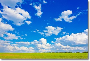
Weather Topic: What are Cumulus Clouds?
Home - Education - Cloud Types - Cumulus Clouds
 Next Topic: Drizzle
Cumulus clouds are fluffy and textured with rounded tops, and
may have flat bottoms. The border of a cumulus cloud
is clearly defined, and can have the appearance of cotton or cauliflower.
Cumulus clouds form at low altitudes (rarely above 2 km) but can grow very tall,
becoming cumulus congestus and possibly the even taller cumulonimbus clouds.
When cumulus clouds become taller, they have a greater chance of producing precipitation.
Next Topic: Drizzle
Weather Topic: What is Evaporation?
Home - Education - Precipitation - Evaporation
 Next Topic: Fog
Evaporation is the process which returns water from the earth
back to the atmosphere, and is another crucial process in the water cycle.
Evaporation is the transformation of liquid into gas, and it happens because
molecules are excited by the application of energy and turn into vapor.
In order for water to evaporate it has to be on the surface of a body of water.
Next Topic: Fog
Current conditions powered by WeatherAPI.com


