Weather Alert in Colorado
Winter Weather Advisory issued February 16 at 7:08PM MST until February 18 at 11:00PM MST by NWS Pueblo CO
AREAS AFFECTED: Western Mosquito Range/East Lake County Above 11000 Ft; Leadville Vicinity/Lake County Below 11000 Ft; Western Chaffee County Between 9000 and 11000 Ft; La Garita Mountains Above 10000 Ft; Upper Rio Grande Valley/Eastern San Juan Mountains Below 10000 Ft
DESCRIPTION: * WHAT...Snow expected. Total snow accumulations between 4 and 12 inches. Winds gusting as high as 75 mph across the higher peaks and lower east facing slopes at times. * WHERE...La Garita Mountains Above 10000 Feet, Lake County Below 11000 Feet, Western Chaffee County Between 9000 and 11000 Feet, Western Mosquito Range Above 11000 Feet, and Upper Rio Grande Valley and Eastern San Juan Mountains Below 10000 Feet. * WHEN...From 11 PM this evening to 11 PM MST Wednesday. * IMPACTS...Travel could be very difficult to impossible. Very strong winds could cause power outages and tree damage.
INSTRUCTION: Slow down and use caution while traveling. The latest road conditions for the state you are calling from can be obtained by calling 5 1 1.
Want more detail? Get the Complete 7 Day and Night Detailed Forecast!
Current U.S. National Radar--Current
The Current National Weather Radar is shown below with a UTC Time (subtract 5 hours from UTC to get Eastern Time).

National Weather Forecast--Current
The Current National Weather Forecast and National Weather Map are shown below.

National Weather Forecast for Tomorrow
Tomorrow National Weather Forecast and Tomorrow National Weather Map are show below.

North America Water Vapor (Moisture)
This map shows recent moisture content over North America. Bright and colored areas show high moisture (ie, clouds); brown indicates very little moisture present; black indicates no moisture.

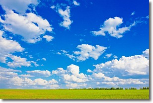
Weather Topic: What are Cumulus Clouds?
Home - Education - Cloud Types - Cumulus Clouds
 Next Topic: Drizzle
Cumulus clouds are fluffy and textured with rounded tops, and
may have flat bottoms. The border of a cumulus cloud
is clearly defined, and can have the appearance of cotton or cauliflower.
Cumulus clouds form at low altitudes (rarely above 2 km) but can grow very tall,
becoming cumulus congestus and possibly the even taller cumulonimbus clouds.
When cumulus clouds become taller, they have a greater chance of producing precipitation.
Next Topic: Drizzle
Weather Topic: What is Evaporation?
Home - Education - Precipitation - Evaporation
 Next Topic: Fog
Evaporation is the process which returns water from the earth
back to the atmosphere, and is another crucial process in the water cycle.
Evaporation is the transformation of liquid into gas, and it happens because
molecules are excited by the application of energy and turn into vapor.
In order for water to evaporate it has to be on the surface of a body of water.
Next Topic: Fog
Current conditions powered by WeatherAPI.com


