Weather Alert in Colorado
Avalanche Watch issued February 16 at 5:16PM MST by NWS Denver CO
AREAS AFFECTED: Grand and Battlement Mesas; Gore and Elk Mountains/Central Mountain Valleys; Flat Tops
DESCRIPTION: AVABOU THE FOLLOWING MESSAGE IS TRANSMITTED AT THE REQUEST OF THE COLORADO AVALANCHE INFORMATION CENTER. AVALANCHE WATCH IN EFFECT FROM 9 AM WEDNESDAY TO 5 PM FRIDAY *WHAT Heavy snow and strong winds will result in HIGH (4 of 5) avalanche danger *WHERE The San Juan Mountains and the Park Range *WHEN Expect very dangerous avalanche conditions to begin Wednesday and last through Friday *IMPACTS Large and dangerous avalanches will be easy to trigger. Large avalanches will run naturally. *PRECAUTION/PREPAREDNESS ACTIONS Travel in backcountry avalanche terrain is not recommended from Wednesday through Friday. Avoid travel on and under slopes with a slope angle steeper than about 30 degrees. You can find more detailed information at colorado.gov/avalanche
INSTRUCTION: N/A
Want more detail? Get the Complete 7 Day and Night Detailed Forecast!
Current U.S. National Radar--Current
The Current National Weather Radar is shown below with a UTC Time (subtract 5 hours from UTC to get Eastern Time).

National Weather Forecast--Current
The Current National Weather Forecast and National Weather Map are shown below.

National Weather Forecast for Tomorrow
Tomorrow National Weather Forecast and Tomorrow National Weather Map are show below.

North America Water Vapor (Moisture)
This map shows recent moisture content over North America. Bright and colored areas show high moisture (ie, clouds); brown indicates very little moisture present; black indicates no moisture.

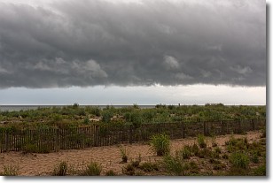
Weather Topic: What are Shelf Clouds?
Home - Education - Cloud Types - Shelf Clouds
 Next Topic: Sleet
A shelf cloud is similar to a wall cloud, but forms at the front
of a storm cloud, instead of at the rear, where wall clouds form.
A shelf cloud is caused by a series of events set into motion by the advancing
storm; first, cool air settles along the ground where precipitation has just fallen.
As the cool air is brought in, the warmer air is displaced, and rises above it,
because it is less dense. When the warmer air reaches the bottom of the storm cloud,
it begins to cool again, and the resulting condensation is a visible shelf cloud.
Next Topic: Sleet
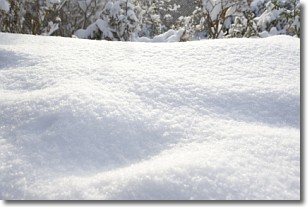
Weather Topic: What is Snow?
Home - Education - Precipitation - Snow
 Next Topic: Stratocumulus Clouds
Snow is precipitation taking the form of ice crystals. Each ice crystal, or snowflake,
has unique characteristics, but all of them grow in a hexagonal structure.
Snowfall can last for sustained periods of time and result in significant buildup
of snow on the ground.
On the earth's surface, snow starts out light and powdery, but as it begins to melt
it tends to become more granular, producing small bits of ice which have the consistency of
sand. After several cycles of melting and freezing, snow can become very dense
and ice-like, commonly known as snow pack.
Next Topic: Stratocumulus Clouds
Current conditions powered by WeatherAPI.com


