Weather Alert in California
Wind Advisory issued March 31 at 12:22AM PDT until April 1 at 11:00PM PDT by NWS Medford OR
AREAS AFFECTED: Modoc County; Central and Eastern Lake County
DESCRIPTION: * WHAT...Southwest winds 20 to 30 mph with gusts up to 45 mph expected. The highest terrain may see gusts up to 55 mph. * WHERE...Central and Eastern Lake County and Modoc County. This includes Fort Rock, Christmas Valley, Silver Lake, Summer Lake, Alkali Lake, Paisley, Valley Falls, Lakeview, Adel, Tionesta, Canby, Alturas, Adin and Likely. This includes parts of Highways 139, 140, 299, 395, and 31. * WHEN...From 11 AM to 11 PM PDT Wednesday. * IMPACTS...Gusty winds will blow around unsecured objects and a few power outages may result. A combination precipitation and gusty winds may cause locally low visibility.
INSTRUCTION: Winds this strong can make driving difficult, especially for high profile vehicles. Use extra caution.
Want more detail? Get the Complete 7 Day and Night Detailed Forecast!
Current U.S. National Radar--Current
The Current National Weather Radar is shown below with a UTC Time (subtract 5 hours from UTC to get Eastern Time).

National Weather Forecast--Current
The Current National Weather Forecast and National Weather Map are shown below.

National Weather Forecast for Tomorrow
Tomorrow National Weather Forecast and Tomorrow National Weather Map are show below.

North America Water Vapor (Moisture)
This map shows recent moisture content over North America. Bright and colored areas show high moisture (ie, clouds); brown indicates very little moisture present; black indicates no moisture.

Weather Topic: What are Altostratus Clouds?
Home - Education - Cloud Types - Altostratus Clouds
 Next Topic: Cirrocumulus Clouds
Altostratus clouds form at mid to high-level altitudes
(between 2 and 7 km) and are created by a warm, stable air mass which causes
water vapor
to condense as it rise through the atmosphere. Usually altostratus clouds are
featureless sheets characterized by a uniform color.
In some cases, wind punching through the cloud formation may give it a waved
appearance, called altostratus undulatus. Altostratus clouds
are commonly seen with other cloud formations accompanying them.
Next Topic: Cirrocumulus Clouds
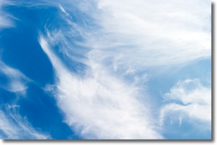
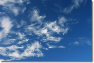
Weather Topic: What are Cirrostratus Clouds?
Home - Education - Cloud Types - Cirrostratus Clouds
 Next Topic: Cirrus Clouds
Cirrostratus clouds are high, thin clouds that form above
20,000 feet and are made mostly of ice crystals. They sometimes look like giant
feathers, horse tails, or curls of hair in the sky.
These clouds are pushed by the jet stream and can move at high speeds reaching
100 mph.
What do they indicate?
They indicate that a precipitation is likely within 24 hours.
Next Topic: Cirrus Clouds
Current conditions powered by WeatherAPI.com


