Weather Alert in New Jersey
Extreme Cold Warning issued February 8 at 1:59AM EST until February 8 at 12:00PM EST by NWS Mount Holly NJ
AREAS AFFECTED: Sussex; Warren; Morris; Berks; Lehigh; Northampton
DESCRIPTION: * WHAT...For the Extreme Cold Warning, dangerously cold wind chills as low as 23 below. For the Cold Weather Advisory, very cold wind chills as low as 13 below expected. * WHERE...In New Jersey, Morris, Sussex, and Warren Counties. In Pennsylvania, Berks, Lehigh, and Northampton Counties. * WHEN...For the Extreme Cold Warning, until noon EST today. For the Cold Weather Advisory, from noon today to 10 AM EST Monday. * IMPACTS...The dangerously cold wind chills as low as 25 below zero could cause frostbite on exposed skin in as little as 30 minutes.
INSTRUCTION: Dress in layers including a hat, face mask, and gloves if you must go outside. Monitor the latest forecasts and warnings for updates. If you do not have heat in your home or lack shelter, you can call 211 for assistance locating appropriate shelter from the cold. Use caution while traveling outside. Wear appropriate clothing, a hat, and gloves.
Want more detail? Get the Complete 7 Day and Night Detailed Forecast!
Current U.S. National Radar--Current
The Current National Weather Radar is shown below with a UTC Time (subtract 5 hours from UTC to get Eastern Time).

National Weather Forecast--Current
The Current National Weather Forecast and National Weather Map are shown below.

National Weather Forecast for Tomorrow
Tomorrow National Weather Forecast and Tomorrow National Weather Map are show below.

North America Water Vapor (Moisture)
This map shows recent moisture content over North America. Bright and colored areas show high moisture (ie, clouds); brown indicates very little moisture present; black indicates no moisture.

Weather Topic: What is Hail?
Home - Education - Precipitation - Hail
 Next Topic: Hole Punch Clouds
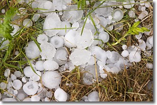
Hail is a form of precipitation which is recognized by large solid balls or
clumps of ice. Hail is created by thunderstorm clouds with strong updrafts of wind.
As the hailstones remain in the updraft, ice is deposited onto them until their
weight becomes heavy enough for them to fall to the earth's surface.
Hail storms can cause significant damage to crops, aircrafts, and man-made structures,
despite the fact that the duration is usually less than ten minutes.
Next Topic: Hole Punch Clouds
Weather Topic: What are Mammatus Clouds?
Home - Education - Cloud Types - Mammatus Clouds
 Next Topic: Nimbostratus Clouds
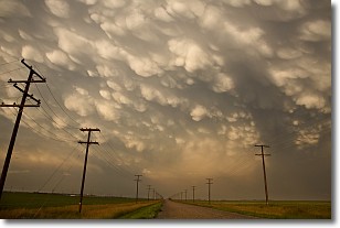
A mammatus cloud is a cloud with a unique feature which resembles
a web of pouches hanging along the base of the cloud.
In the United States, mammatus clouds tend to form in the warmer months, commonly
in the Midwest and eastern regions.
While they usually form at the bottom of a cumulonimbis cloud, they can also form
under altostratus, altocumulus, stratocumulus, and cirrus clouds. Mammatus clouds
warn that severe weather is close.
Next Topic: Nimbostratus Clouds
Current conditions powered by WeatherAPI.com


