Weather Alert in New Mexico
High Wind Warning issued February 16 at 10:51PM MST until February 17 at 8:00PM MST by NWS Albuquerque NM
AREAS AFFECTED: Glorieta Mesa Including Glorieta Pass; East Slopes Sangre de Cristo Mountains; Central Highlands; South Central Mountains; Johnson and Bartlett Mesas Including Raton Pass; Far Northeast Highlands; Northeast Highlands; Union County; Harding County; Eastern San Miguel County; Guadalupe County; Quay County; Curry County; Roosevelt County; De Baca County; Chaves County Plains; Eastern Lincoln County; Southwest Chaves County
DESCRIPTION: * WHAT...Southwest to west winds 35 to 45 mph with gusts up to 70 mph expected. * WHERE...All of eastern New Mexico as well as the east slopes of the Sangre de Cristo Mountains, the Northeast and Central Highlands as well as the South Central Mountains. * WHEN...From 8 AM to 8 PM MST Tuesday. * IMPACTS...Damaging winds could blow down trees and power lines. Power outages are possible. Travel will be difficult, especially for high profile vehicles. * ADDITIONAL DETAILS...Patchy blowing dust may develop across the eastern plains due to the very strong west winds and dry antecedent conditions. Visibility may be reduced below one mile.
INSTRUCTION: Take action to secure trash cans, lawn furniture, and other loose or lightweight outdoor objects. Extremely hazardous driving conditions can be expected, especially for motorists in high profile vehicles who should consider delaying travel.
Want more detail? Get the Complete 7 Day and Night Detailed Forecast!
Current U.S. National Radar--Current
The Current National Weather Radar is shown below with a UTC Time (subtract 5 hours from UTC to get Eastern Time).

National Weather Forecast--Current
The Current National Weather Forecast and National Weather Map are shown below.

National Weather Forecast for Tomorrow
Tomorrow National Weather Forecast and Tomorrow National Weather Map are show below.

North America Water Vapor (Moisture)
This map shows recent moisture content over North America. Bright and colored areas show high moisture (ie, clouds); brown indicates very little moisture present; black indicates no moisture.

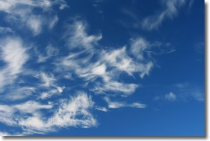
Weather Topic: What are Altostratus Clouds?
Home - Education - Cloud Types - Altostratus Clouds
 Next Topic: Cirrocumulus Clouds
Altostratus clouds form at mid to high-level altitudes
(between 2 and 7 km) and are created by a warm, stable air mass which causes
water vapor
to condense as it rise through the atmosphere. Usually altostratus clouds are
featureless sheets characterized by a uniform color.
In some cases, wind punching through the cloud formation may give it a waved
appearance, called altostratus undulatus. Altostratus clouds
are commonly seen with other cloud formations accompanying them.
Next Topic: Cirrocumulus Clouds
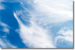
Weather Topic: What are Cirrostratus Clouds?
Home - Education - Cloud Types - Cirrostratus Clouds
 Next Topic: Cirrus Clouds
Cirrostratus clouds are high, thin clouds that form above
20,000 feet and are made mostly of ice crystals. They sometimes look like giant
feathers, horse tails, or curls of hair in the sky.
These clouds are pushed by the jet stream and can move at high speeds reaching
100 mph.
What do they indicate?
They indicate that a precipitation is likely within 24 hours.
Next Topic: Cirrus Clouds
Current conditions powered by WeatherAPI.com


