Weather Alert in Alaska
Hydrologic Outlook issued August 24 at 8:36PM AKDT by NWS Anchorage AK
AREAS AFFECTED: Kuskokwim Valley West; Kuskokwim Valley East; Interior Kuskokwim Delta; Western Capes; Northern Bristol Bay Coast; Inland Bristol Bay
DESCRIPTION: ESFAFC Prolonged, widespread rainfall is expected across Southwest Alaska this week. Steadier rainfall, which can be moderate to heavy at times, is expected to begin Monday and last through at least Wednesday with showers lingering through the rest of the week. Widespread rainfall totals of 1.5 to 3 inches is expected with locally higher amounts possible. The highest rainfall totals of at least 2.5 to 4 inches is expected close to the mountains near Togiak and the Western Capes. Expect water levels to rise along small streams and rivers, especially in areas of steeper terrain.
INSTRUCTION: N/A
Want more detail? Get the Complete 7 Day and Night Detailed Forecast!
Current U.S. National Radar--Current
The Current National Weather Radar is shown below with a UTC Time (subtract 5 hours from UTC to get Eastern Time).

National Weather Forecast--Current
The Current National Weather Forecast and National Weather Map are shown below.

National Weather Forecast for Tomorrow
Tomorrow National Weather Forecast and Tomorrow National Weather Map are show below.

North America Water Vapor (Moisture)
This map shows recent moisture content over North America. Bright and colored areas show high moisture (ie, clouds); brown indicates very little moisture present; black indicates no moisture.

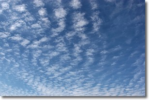
Weather Topic: What are Cirrocumulus Clouds?
Home - Education - Cloud Types - Cirrocumulus Clouds
 Next Topic: Cirrostratus Clouds
Cirrocumulus clouds form at high altitudes (usually around 5 km)
and have distinguishing characteristics displayed in a fine layer of
small cloud patches. These small cloud patches are sometimes referred to as
"cloudlets" in relation to the whole cloud formation.
Cirrocumulus clouds are formed from ice crystals and water droplets. Often, the
water droplets in the cloud freeze into ice crystals and the cloud becomes a
cirrostratus cloud. Because of this common occurrence, cirrocumulus cloud
formations generally pass rapidly.
Next Topic: Cirrostratus Clouds
Weather Topic: What are Cirrus Clouds?
Home - Education - Cloud Types - Cirrus Clouds
 Next Topic: Condensation
Cirrus clouds are high-level clouds that occur above 20,000 feet
and are composed mainly of ice crystals.
They are thin and wispy in appearance.
What do they indicate?
They are often the first sign of an approaching storm.
Next Topic: Condensation
Current conditions powered by WeatherAPI.com


