Weather Alert in Kansas
Red Flag Warning issued February 16 at 1:45PM MST until February 17 at 8:00PM MST by NWS Goodland KS
AREAS AFFECTED: Decatur; Norton; Thomas; Sheridan; Graham; Logan; Gove; Wichita; Red Willow
DESCRIPTION: For Tuesday, low relative humidity and sustained winds around 40 mph will lead to extreme fire spread for any fires that ignite. Southwest winds will change to west behind a cold front in the afternoon. Blowing dust may also occur near open fields or other source regions causing reductions in visibility and poor air quality. * AFFECTED AREA...Fire Weather Zones 003 Decatur, 004 Norton, 014 Thomas, 015 Sheridan, 016 Graham, 028 Logan, 029 Gove, 042 Wichita and 081 Red Willow. * TIMING...From 11 AM to 9 PM CST Tuesday. * WINDS...West 30 to 40 mph with gusts up to 60 mph. * RELATIVE HUMIDITY...As low as 10 percent. * IMPACTS...Extremely dangerous and erratic fire behavior. Any fires that develop will rapidly grow and spread out of control.
INSTRUCTION: Comply with burn bans and regulations. Avoid driving on dry grass or brush. Maintain vehicle brakes and tires and secure tow chains to avoid dragging. Never toss lit cigarettes onto the ground. Evacuate if fire/smoke is heading your way, or if ordered to do so by local officials.
Want more detail? Get the Complete 7 Day and Night Detailed Forecast!
Current U.S. National Radar--Current
The Current National Weather Radar is shown below with a UTC Time (subtract 5 hours from UTC to get Eastern Time).

National Weather Forecast--Current
The Current National Weather Forecast and National Weather Map are shown below.

National Weather Forecast for Tomorrow
Tomorrow National Weather Forecast and Tomorrow National Weather Map are show below.

North America Water Vapor (Moisture)
This map shows recent moisture content over North America. Bright and colored areas show high moisture (ie, clouds); brown indicates very little moisture present; black indicates no moisture.

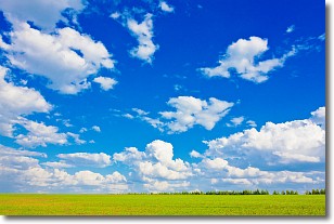
Weather Topic: What are Cumulus Clouds?
Home - Education - Cloud Types - Cumulus Clouds
 Next Topic: Drizzle
Cumulus clouds are fluffy and textured with rounded tops, and
may have flat bottoms. The border of a cumulus cloud
is clearly defined, and can have the appearance of cotton or cauliflower.
Cumulus clouds form at low altitudes (rarely above 2 km) but can grow very tall,
becoming cumulus congestus and possibly the even taller cumulonimbus clouds.
When cumulus clouds become taller, they have a greater chance of producing precipitation.
Next Topic: Drizzle
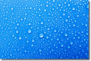
Weather Topic: What is Evaporation?
Home - Education - Precipitation - Evaporation
 Next Topic: Fog
Evaporation is the process which returns water from the earth
back to the atmosphere, and is another crucial process in the water cycle.
Evaporation is the transformation of liquid into gas, and it happens because
molecules are excited by the application of energy and turn into vapor.
In order for water to evaporate it has to be on the surface of a body of water.
Next Topic: Fog
Current conditions powered by WeatherAPI.com


