Weather Alert in Kansas
Red Flag Warning issued February 16 at 1:45PM MST until February 17 at 8:00PM MST by NWS Goodland KS
AREAS AFFECTED: Decatur; Norton; Thomas; Sheridan; Graham; Logan; Gove; Wichita; Red Willow
DESCRIPTION: For Tuesday, low relative humidity and sustained winds around 40 mph will lead to extreme fire spread for any fires that ignite. Southwest winds will change to west behind a cold front in the afternoon. Blowing dust may also occur near open fields or other source regions causing reductions in visibility and poor air quality. * AFFECTED AREA...Fire Weather Zones 003 Decatur, 004 Norton, 014 Thomas, 015 Sheridan, 016 Graham, 028 Logan, 029 Gove, 042 Wichita and 081 Red Willow. * TIMING...From 11 AM to 9 PM CST Tuesday. * WINDS...West 30 to 40 mph with gusts up to 60 mph. * RELATIVE HUMIDITY...As low as 10 percent. * IMPACTS...Extremely dangerous and erratic fire behavior. Any fires that develop will rapidly grow and spread out of control.
INSTRUCTION: Comply with burn bans and regulations. Avoid driving on dry grass or brush. Maintain vehicle brakes and tires and secure tow chains to avoid dragging. Never toss lit cigarettes onto the ground. Evacuate if fire/smoke is heading your way, or if ordered to do so by local officials.
Want more detail? Get the Complete 7 Day and Night Detailed Forecast!
Current U.S. National Radar--Current
The Current National Weather Radar is shown below with a UTC Time (subtract 5 hours from UTC to get Eastern Time).

National Weather Forecast--Current
The Current National Weather Forecast and National Weather Map are shown below.

National Weather Forecast for Tomorrow
Tomorrow National Weather Forecast and Tomorrow National Weather Map are show below.

North America Water Vapor (Moisture)
This map shows recent moisture content over North America. Bright and colored areas show high moisture (ie, clouds); brown indicates very little moisture present; black indicates no moisture.

Weather Topic: What are Hole Punch Clouds?
Home - Education - Cloud Types - Hole Punch Clouds
 Next Topic: Mammatus Clouds
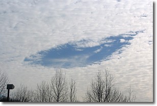
A hole punch cloud is an unusual occurrence when a disk-shaped
hole appears in a cirrostratus, cirrocumulus, or altocumulus cloud.
When part of the cloud forms ice crystals, water droplets in the surrounding area
of the cloud evaporate. The effect of this process produces a large elliptical
gap in the cloud. The hole punch cloud formation is rare, but it is not specific
to any geographic area.
Other names which have been used to describe this phenomena include fallstreak hole,
skypunch, and cloud hole.
Next Topic: Mammatus Clouds
Weather Topic: What are Nimbostratus Clouds?
Home - Education - Cloud Types - Nimbostratus Clouds
 Next Topic: Precipitation
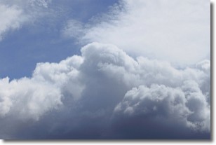
A nimbostratus cloud is similar to a stratus cloud in its formless,
smooth appearance. However, a nimbostratus cloud is darker than a stratus cloud,
because it is thicker.
Unlike a stratus cloud, a nimbostratus cloud typically brings with it the threat
of moderate to heavy precipitation. In some cases, the precipitation may evaporate
before reaching the ground, a phenomenon known as virga.
Next Topic: Precipitation
Current conditions powered by WeatherAPI.com


