Weather Alert in Alaska
Hydrologic Outlook issued August 27 at 2:38PM AKDT by NWS Anchorage AK
AREAS AFFECTED: Anchorage; Anchorage Hillside / Eagle River; East Turnagain Arm; Portage; Lower Matanuska Valley; Hatcher Pass; Sutton / Upper Matanuska Valley; Eureka / Tahneta Pass; Southern Kachemak Bay; SW Kenai Peninsula; NW Kenai Peninsula; Skilak Lake; Southern Kenai Mtns; Interior Kenai Peninsula; Turnagain Pass; West Prince William Sound & Whittier; Tyonek; Valdez; Thompson Pass; Cordova; Western Susitna Valley; Southern Susitna Valley; Central Susitna Valley; Northern Susitna Valley
DESCRIPTION: ESFAFC Rainfall * Eastern Kenai Peninsula and Prince William Sound: 2 to 5 inches with locally higher amounts in higher terrain. * Mat-Su Valley: 1.5 to 4 inches with locally higher amounts. The highest rainfall totals are likely to be across the northern Susitna Valley. * Western Kenai Peninsula and Anchorage: 1 to 2 inches of rainfall with the heaviest rainfall occuring adjacent to Cook Inlet. Downsloping at times may result in localized lower amounts immediately west of the mountains. Hydrologic Concerns * Expect sharp rises on many small streams and rivers. Many smaller streams will crest Thursday night into Friday while larger rivers or downstream points may crest Friday and Saturday. Higher than normal water levels may continue through Labor Day Weekend into next week. * Many lower locations along rivers such as gravel bars and other spots popular for camping and recreating are likely to become inundated with water. * Heavy rain may result in localized ponding in low-lying areas and locations with poor drainage. Confidence and Next Steps * Confidence is high that a multi-day heavy rainfall event will occur across Southcentral Alaska, with the northern Susitna Valley and Prince William Sound receiving the heaviest rainfall. Confidence is medium regarding rainfall totals and placement of heaviest rainfall. If forecast rainfall totals hold or increase, flood watches may be needed for portions of the Kenai Peninsula, Mat-Su Valley, or elsewhere. * Residents along area streams as well as river users and recreationists should anticipate higher than normal water levels and are advised to monitor weather and river forecasts. * Reports on river conditions may be sent to the river forecast center by calling 1-800-847-1739.
INSTRUCTION: N/A
Want more detail? Get the Complete 7 Day and Night Detailed Forecast!
Current U.S. National Radar--Current
The Current National Weather Radar is shown below with a UTC Time (subtract 5 hours from UTC to get Eastern Time).

National Weather Forecast--Current
The Current National Weather Forecast and National Weather Map are shown below.

National Weather Forecast for Tomorrow
Tomorrow National Weather Forecast and Tomorrow National Weather Map are show below.

North America Water Vapor (Moisture)
This map shows recent moisture content over North America. Bright and colored areas show high moisture (ie, clouds); brown indicates very little moisture present; black indicates no moisture.

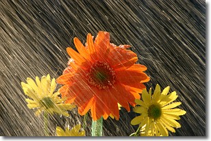
Weather Topic: What is Rain?
Home - Education - Precipitation - Rain
 Next Topic: Shelf Clouds
Precipitation in the form of water droplets is called rain.
Rain generally has a tendency to fall with less intensity over a greater period
of time, and when rainfall is more severe it is usually less sustained.
Rain is the most common form of precipitation and happens with greater frequency
depending on the season and regional influences. Cities have been shown to have
an observable effect on rainfall, due to an effect called the urban heat island.
Compared to upwind, monthly rainfall between twenty and forty miles downwind of
cities is 30% greater.
Next Topic: Shelf Clouds
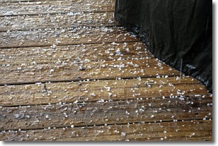
Weather Topic: What is Sleet?
Home - Education - Precipitation - Sleet
 Next Topic: Snow
Sleet is a form of precipitation in which small ice pellets are the primary
components. These ice pellets are smaller and more translucent than hailstones,
and harder than graupel. Sleet is caused by specific atmospheric conditions and
therefore typically doesn't last for extended periods of time.
The condition which leads to sleet formation requires a warmer body of air to be
wedged in between two sub-freezing bodies of air. When snow falls through a warmer
layer of air it melts, and as it falls through the next sub-freezing body of air
it freezes again, forming ice pellets known as sleet. In some cases, water
droplets don't have time to freeze before reaching the surface and the result is
freezing rain.
Next Topic: Snow
Current conditions powered by WeatherAPI.com


