Weather Alert in Idaho
Avalanche Watch issued February 16 at 6:24AM MST by NWS Pocatello ID
AREAS AFFECTED: Bear River Range
DESCRIPTION: AVAPIH * WHAT...Avalanche watch. Heavy snowfall and strong winds are expected to rapidly increase avalanche danger across northern Utah and southeast Idaho beginning Tuesday and continuing throughout the week. Expect dangerous and complex avalanche conditions to develop on many slopes, with large and natural and human- triggered avalanches likely. * WHERE...The Bear River Range and Wasatch Mountains. * WHEN...6 AM MST Monday through 6 AM MST Tuesday * IMPACTS...Dangerous avalanche conditions are expected to develop on many slopes. Avalanches can be triggered on slopes steeper than 30 degrees. They may also be triggered remotely from a distance or from below.
INSTRUCTION: Avoid traveling on or underneath steep terrain at mid and upper elevations in the backcountry. Carry and know how to use avalanche rescue equipment, including a transceiver, shovel and probe. Find safer riding conditions on slopes less than 30 degrees with no overhead hazard. Consult www.utahavalanchecenter.org or www.avalanche.org for more detailed information. Similar avalanche danger may exist at locations outside the coverage area of this or any avalanche center.
Want more detail? Get the Complete 7 Day and Night Detailed Forecast!
Current U.S. National Radar--Current
The Current National Weather Radar is shown below with a UTC Time (subtract 5 hours from UTC to get Eastern Time).

National Weather Forecast--Current
The Current National Weather Forecast and National Weather Map are shown below.

National Weather Forecast for Tomorrow
Tomorrow National Weather Forecast and Tomorrow National Weather Map are show below.

North America Water Vapor (Moisture)
This map shows recent moisture content over North America. Bright and colored areas show high moisture (ie, clouds); brown indicates very little moisture present; black indicates no moisture.

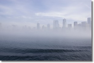
Weather Topic: What is Fog?
Home - Education - Cloud Types - Fog
 Next Topic: Fractus Clouds
Fog is technically a type of stratus cloud, which lies along the
ground and obscures visibility.
It is usually created when humidity in the air condenses into tiny water droplets.
Because of this, some places are more prone to foggy weather, such as regions
close to a body of water.
Fog is similar to mist; both are the appearance of water droplets suspended in
the air, but fog is the term applied to the condition when visibility is less than 1 km.
Next Topic: Fractus Clouds
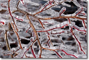
Weather Topic: What is Freezing Rain?
Home - Education - Precipitation - Freezing Rain
 Next Topic: Graupel
Freezing rain is a condition where precipitation which has fallen in the form of
water droplets reaches temperatures which are below freezing and freezes upon
coming into contact
with surface objects. The result of this precipitation is a glaze of ice which
can be damaging to plants and man-made structures. A severe onset of freezing
rain which results in a very thick glaze of ice is known as an ice storm.
Next Topic: Graupel
Current conditions powered by WeatherAPI.com


