Weather Alert in Nebraska
Fire Weather Watch issued February 16 at 7:25AM CST until February 17 at 8:00PM CST by NWS North Platte NE
AREAS AFFECTED: Eastern Panhandle/Crescent Lake NWR; Sandhills/Valentine NWR/Nebraska National Forest; Niobrara Valley/Fort Niobrara NWR/Samuel R McKelvie National Forest; Loup Rivers Basin; Frenchman Basin; Loess Plains
DESCRIPTION: ...CRITICAL FIRE WEATHER CONDITIONS PROBABLE TUESDAY AFTERNOON THROUGH MID EVENING... .Intense low pressure will develop over southern South Dakota Tuesday morning. The strong west winds will combine with very dry air, leading to probable critical fire weather conditions across all of western and north central Nebraska Tuesday afternoon into the mid evening hours. * AFFECTED AREA...Fire Weather Zone 204 Eastern Panhandle/Crescent Lake NWR, Fire Weather Zone 206 Sandhills/Valentine NWR/Nebraska National Forest, Fire Weather Zone 208 Niobrara Valley/Fort Niobrara NWR/Samuel R McKelvie National Forest, Fire Weather Zone 209 Loup Rivers Basin, Fire Weather Zone 210 Frenchman Basin and Fire Weather Zone 219 Loess Plains. * TIMING...Noon to 8 PM CST (11 AM to 7 PM MST) Tuesday. * WINDS...West 25 to 35 mph with gusts up to 55 mph, strongest winds west of Highway 83. * RELATIVE HUMIDITY...As low as 10 to 15 percent. * TEMPERATURES...Mid 60s to mid 70s. * LIGHTNING...None expected. * IMPACTS...Any fire starts will have a high potential to spread rapidly and will be difficult to control.
INSTRUCTION: A Fire Weather Watch means that critical fire weather conditions are forecast to occur. Listen for later forecasts and possible Red Flag Warnings.
Want more detail? Get the Complete 7 Day and Night Detailed Forecast!
Current U.S. National Radar--Current
The Current National Weather Radar is shown below with a UTC Time (subtract 5 hours from UTC to get Eastern Time).

National Weather Forecast--Current
The Current National Weather Forecast and National Weather Map are shown below.

National Weather Forecast for Tomorrow
Tomorrow National Weather Forecast and Tomorrow National Weather Map are show below.

North America Water Vapor (Moisture)
This map shows recent moisture content over North America. Bright and colored areas show high moisture (ie, clouds); brown indicates very little moisture present; black indicates no moisture.

Weather Topic: What are Contrails?
Home - Education - Cloud Types - Contrails
 Next Topic: Cumulonimbus Clouds
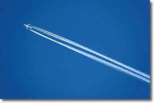
A contrail is an artificial cloud, created by the passing of an
aircraft.
Contrails form because water vapor in the exhaust of aircraft engines is suspended
in the air under certain temperatures and humidity conditions. These contrails
are called exhaust contrails.
Another type of contrail can form due to a temporary reduction in air pressure
moving over the plane's surface, causing condensation.
These are called aerodynamic contrails.
When you can see your breath on a cold day, it is also because of condensation.
The reason contrails last longer than the condensation from your breath is
because the water in contrails freezes into ice particles.
Next Topic: Cumulonimbus Clouds
Weather Topic: What are Cumulus Clouds?
Home - Education - Cloud Types - Cumulus Clouds
 Next Topic: Drizzle
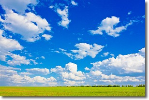
Cumulus clouds are fluffy and textured with rounded tops, and
may have flat bottoms. The border of a cumulus cloud
is clearly defined, and can have the appearance of cotton or cauliflower.
Cumulus clouds form at low altitudes (rarely above 2 km) but can grow very tall,
becoming cumulus congestus and possibly the even taller cumulonimbus clouds.
When cumulus clouds become taller, they have a greater chance of producing precipitation.
Next Topic: Drizzle
Current conditions powered by WeatherAPI.com


