Weather Alert in Colorado
High Wind Warning issued February 16 at 5:59PM MST until February 17 at 5:00PM MST by NWS Goodland KS
AREAS AFFECTED: Yuma County; Kit Carson County; Cheyenne County; Sherman; Thomas; Wallace; Logan; Gove; Greeley; Wichita
DESCRIPTION: * WHAT...West winds 35 to 45 mph with gusts up to 65 mph expected. * WHERE...Portions of east central and northeast Colorado and northwest and west central Kansas. * WHEN...From 10 AM MST /11 AM CST/ to 5 PM MST /6 PM CST/ Tuesday. * IMPACTS...High winds may move loose debris, damage property and cause power outages. Travel could be difficult, especially for high profile vehicles. Plumes of blowing dust will create pockets of low visibility. Visibilities will likely change rapidly over short distances, making travel hazardous in these areas. * ADDITIONAL DETAILS...Strongest winds are forecast to be during the late morning through the mid afternoon hours. Strong sustained winds around 40 mph will persist through afternoon.
INSTRUCTION: Fasten loose objects or shelter objects in a safe location prior to the onset of winds. Winds this strong can make driving difficult, especially for high profile vehicles. Use extra caution. Blowing dust can significantly lower air quality and it is encouraged that you take preventative measures such as staying indoors or wearing protective breathing masks if outside. High dust concentrations can cause respiratory problems, decrease lung activity, aggravate asthma, and lead to potential heart-related problems, especially with children, elderly or those with pre-existing respiratory conditions.
Want more detail? Get the Complete 7 Day and Night Detailed Forecast!
Current U.S. National Radar--Current
The Current National Weather Radar is shown below with a UTC Time (subtract 5 hours from UTC to get Eastern Time).

National Weather Forecast--Current
The Current National Weather Forecast and National Weather Map are shown below.

National Weather Forecast for Tomorrow
Tomorrow National Weather Forecast and Tomorrow National Weather Map are show below.

North America Water Vapor (Moisture)
This map shows recent moisture content over North America. Bright and colored areas show high moisture (ie, clouds); brown indicates very little moisture present; black indicates no moisture.

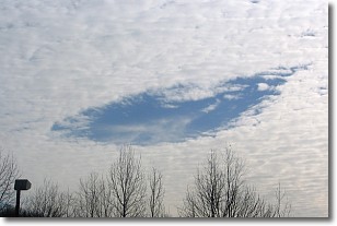
Weather Topic: What are Hole Punch Clouds?
Home - Education - Cloud Types - Hole Punch Clouds
 Next Topic: Mammatus Clouds
A hole punch cloud is an unusual occurrence when a disk-shaped
hole appears in a cirrostratus, cirrocumulus, or altocumulus cloud.
When part of the cloud forms ice crystals, water droplets in the surrounding area
of the cloud evaporate. The effect of this process produces a large elliptical
gap in the cloud. The hole punch cloud formation is rare, but it is not specific
to any geographic area.
Other names which have been used to describe this phenomena include fallstreak hole,
skypunch, and cloud hole.
Next Topic: Mammatus Clouds
Weather Topic: What are Nimbostratus Clouds?
Home - Education - Cloud Types - Nimbostratus Clouds
 Next Topic: Precipitation
A nimbostratus cloud is similar to a stratus cloud in its formless,
smooth appearance. However, a nimbostratus cloud is darker than a stratus cloud,
because it is thicker.
Unlike a stratus cloud, a nimbostratus cloud typically brings with it the threat
of moderate to heavy precipitation. In some cases, the precipitation may evaporate
before reaching the ground, a phenomenon known as virga.
Next Topic: Precipitation
Current conditions powered by WeatherAPI.com


