Weather Alert in Alaska
Cold Weather Advisory issued February 27 at 8:47PM AKST until February 28 at 10:00AM AKST by NWS Anchorage AK
AREAS AFFECTED: Southern Kachemak Bay; SW Kenai Peninsula; NW Kenai Peninsula; Skilak Lake; Southern Kenai Mtns
DESCRIPTION: * WHAT...For Seward and the Kachemak Bay region, very cold wind chills as low as 10 below zero. For the Western Kenai Peninsula, from Ninilchik to Sterling, very cold wind chills as low as 30 below zero. * WHERE...Western Kenai Peninsula, and Southern Kenai Mtns. * WHEN...Until 10 AM AKST Saturday. * IMPACTS...The dangerously cold wind chills as low as 30 below zero could cause frostbite on exposed skin in as little as 10 minutes. * ADDITIONAL DETAILS...Overnight low temperatures will again fall to around 10 and 30 below zero across the Southern and Western Kenai Peninsula, respectively. For areas from Homer to Seward, expect wind chill values overnight to as low 10 below. For areas from Ninilchik to Sterling, expect wind chill values and or overnight temperatures to fall as low as 25 to 30 below zero.
INSTRUCTION: Use caution while traveling outside. Wear appropriate clothing, a hat, and gloves.
Want more detail? Get the Complete 7 Day and Night Detailed Forecast!
Current U.S. National Radar--Current
The Current National Weather Radar is shown below with a UTC Time (subtract 5 hours from UTC to get Eastern Time).

National Weather Forecast--Current
The Current National Weather Forecast and National Weather Map are shown below.

National Weather Forecast for Tomorrow
Tomorrow National Weather Forecast and Tomorrow National Weather Map are show below.

North America Water Vapor (Moisture)
This map shows recent moisture content over North America. Bright and colored areas show high moisture (ie, clouds); brown indicates very little moisture present; black indicates no moisture.

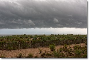
Weather Topic: What are Shelf Clouds?
Home - Education - Cloud Types - Shelf Clouds
 Next Topic: Sleet
A shelf cloud is similar to a wall cloud, but forms at the front
of a storm cloud, instead of at the rear, where wall clouds form.
A shelf cloud is caused by a series of events set into motion by the advancing
storm; first, cool air settles along the ground where precipitation has just fallen.
As the cool air is brought in, the warmer air is displaced, and rises above it,
because it is less dense. When the warmer air reaches the bottom of the storm cloud,
it begins to cool again, and the resulting condensation is a visible shelf cloud.
Next Topic: Sleet
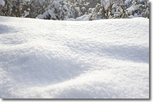
Weather Topic: What is Snow?
Home - Education - Precipitation - Snow
 Next Topic: Stratocumulus Clouds
Snow is precipitation taking the form of ice crystals. Each ice crystal, or snowflake,
has unique characteristics, but all of them grow in a hexagonal structure.
Snowfall can last for sustained periods of time and result in significant buildup
of snow on the ground.
On the earth's surface, snow starts out light and powdery, but as it begins to melt
it tends to become more granular, producing small bits of ice which have the consistency of
sand. After several cycles of melting and freezing, snow can become very dense
and ice-like, commonly known as snow pack.
Next Topic: Stratocumulus Clouds
Current conditions powered by WeatherAPI.com


