Weather Alert in Wisconsin
Severe Thunderstorm Warning issued April 2 at 6:35PM CDT until April 2 at 7:15PM CDT by NWS Milwaukee/Sullivan WI
AREAS AFFECTED: Dane, WI; Green, WI; Iowa, WI
DESCRIPTION: SVRMKX The National Weather Service in Milwaukee/Sullivan has issued a * Severe Thunderstorm Warning for... Northern Green County in south central Wisconsin... Southeastern Iowa County in south central Wisconsin... Western Dane County in south central Wisconsin... * Until 715 PM CDT. * At 635 PM CDT, severe thunderstorms were located along a line extending from 9 miles west of Mount Horeb to near Blanchardville, moving northeast at 50 mph. HAZARD...60 mph wind gusts and quarter size hail. SOURCE...Radar indicated. IMPACT...Hail damage to vehicles is expected. Expect wind damage to roofs, siding, and trees. * Locations impacted include... Madison, Fitchburg, Middleton, Waunakee, Verona, Oregon, Monona, Mount Horeb, Windsor, Prairie Du Sac, Sauk City, Deforest, Cross Plains, Belleville, New Glarus, Mazomanie, Shorewood Hills, Brooklyn, Black Earth, and Maple Bluff. Other landmarks included are the following Locations York Memorial Church and Wisconsin State Capitol.
INSTRUCTION: For your protection move to an interior room on the lowest floor of a building. A Tornado Watch remains in effect until 800 PM CDT for south central Wisconsin.
Want more detail? Get the Complete 7 Day and Night Detailed Forecast!
Current U.S. National Radar--Current
The Current National Weather Radar is shown below with a UTC Time (subtract 5 hours from UTC to get Eastern Time).

National Weather Forecast--Current
The Current National Weather Forecast and National Weather Map are shown below.

National Weather Forecast for Tomorrow
Tomorrow National Weather Forecast and Tomorrow National Weather Map are show below.

North America Water Vapor (Moisture)
This map shows recent moisture content over North America. Bright and colored areas show high moisture (ie, clouds); brown indicates very little moisture present; black indicates no moisture.

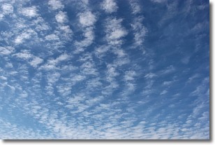
Weather Topic: What are Altocumulus Clouds?
Home - Education - Cloud Types - Altocumulus Clouds
 Next Topic: Altostratus Clouds
Similar to cirrocumulus clouds, altocumulus clouds are
characterized by cloud patches. They are distinguished by larger cloudlets
than cirrocumulus clouds but are still smaller than stratocumulus clouds.
Altocumulus clouds most commonly form in middle altitudes (between 2 and 5 km)
and may resemble, at times, the shape of a flying saucer.
These uncommon formations, called altocumulus lenticularis, are created by uplift
in the atmosphere and are most often seen in close proximity to mountains.
Next Topic: Altostratus Clouds
Weather Topic: What are Cirrocumulus Clouds?
Home - Education - Cloud Types - Cirrocumulus Clouds
 Next Topic: Cirrostratus Clouds
Cirrocumulus clouds form at high altitudes (usually around 5 km)
and have distinguishing characteristics displayed in a fine layer of
small cloud patches. These small cloud patches are sometimes referred to as
"cloudlets" in relation to the whole cloud formation.
Cirrocumulus clouds are formed from ice crystals and water droplets. Often, the
water droplets in the cloud freeze into ice crystals and the cloud becomes a
cirrostratus cloud. Because of this common occurrence, cirrocumulus cloud
formations generally pass rapidly.
Next Topic: Cirrostratus Clouds
Current conditions powered by WeatherAPI.com


